Welcome to Tesla Motors Club
Discuss Tesla's Model S, Model 3, Model X, Model Y, Cybertruck, Roadster and More.
Register

Estimate charge % LEAVING supercharger?

This site may earn commission on affiliate links.
Hi all,
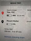
Wanting to take my new SR+ to Mt Bulla from Melbourne. The trip planner shows a 25min stop at the Yea supercharger to arrive at Mt Bulla with 17%.
This would be a day trip, so realistically need to be able to get from Yea, up the mountain and back to Yea without charging. That distance is 250km round trip so should be doable.
I’m yet to supercharge my car, but is there anyway to know what % the trip planner is planning to charge to? Meaning, does it just charge enough to get me to the destination with an arbitrary amount? Or is there anyway I can do a round trip without having to be in Yea?
 

Attachments

  • image.jpg
    image.jpg
    1 MB · Views: 63
Yes I’ve had a play with that and seems very helpful. How accurate is it? Not interested in exacts, but wondered if it took in to account the climb up the mountain?
You can test if the climb has been accounted for by putting in a one way trip to your destination. If its half the two way trip then no, as you’ll use a lot more going up and regenerate a lot coming down
 
The % is what you arrive at the supercharger with & then the destination having supercharged. If you remove the Supercharge it will just show destination arrival % as you discovered.

It takes into account terrain. You can verify this simply by opening the energy graph after you enter a route. Where the green line is going up it has you going downhill. In this example the route is taking me up Mt BawBaw. You can see how it steepens at the end & the terrain enroute.
Note that the energy graph only displays to you next charge point. So you will have to program direct to Buller to see it that ascent. Otherwise it will just show to Yea.

1623658934230.png
 
The % is what you arrive at the supercharger with & then the destination having supercharged. If you remove the Supercharge it will just show destination arrival % as you discovered.

It takes into account terrain. You can verify this simply by opening the energy graph after you enter a route. Where the green line is going up it has you going downhill. In this example the route is taking me up Mt BawBaw. You can see how it steepens at the end & the terrain enroute.
Note that the energy graph only displays to you next charge point. So you will have to program direct to Buller to see it that ascent. Otherwise it will just show to Yea.

View attachment 673224
Thanks, that’s helpful.
 
Yes I’ve had a play with that and seems very helpful. How accurate is it? Not interested in exacts, but wondered if it took in to account the climb up the mountain?
ABRP is fairly accurate - in my experience, more so than the in-car planner (it's a bit less optimistic in general). Neither of them take into account additional draw from the climate control, from what I can tell.

ABRP does take into account altitude changes, as well as speed (this can be a source of inaccuracy if it's missing speed limit data for some C roads - if you click on any point of the route you get a little pop up showing expected the altitude and speed there). It can also take into account temperature/weather, and additional weight, if you go into the detailed options.
 
  • Helpful
Reactions: paulp