


Welcome to Tesla Motors Club
Discuss Tesla's Model S, Model 3, Model X, Model Y, Cybertruck, Roadster and More.
Register
Install the app
How to install the app on iOS
You can install our site as a web app on your iOS device by utilizing the Add to Home Screen feature in Safari. Please see this thread for more details on this.
Note: This feature may not be available in some browsers.
-
Want to remove ads? Register an account and login to see fewer ads, and become a Supporting Member to remove almost all ads.
You are using an out of date browser. It may not display this or other websites correctly.
You should upgrade or use an alternative browser.
You should upgrade or use an alternative browser.
Wiki Largest gaps between Superchargers on US Interstates
- Thread starter ItsNotAboutTheMoney
- Start date

Jeremy3292
Active Member
It's already on the map as a "Coming Soon" location...Add Henryetta OK (largest gap in US per list)supercharger here (Supercharger Voting | Tesla). It does not appear on the list but you can add it.
It's already on the map as a "Coming Soon" location...
According to the thread for that site, the Findus map has shown Coming Soon for Henryetta OK since 2016 !
I don't think Tesla is waiting for people to vote on it; I think they can't make a deal with a host site for some reason. (Maybe the whole town thinks they can stop the transition to electric vehicle and save the fossil fuel industry.)

Supercharger - Henryetta, OK
The Supercharger in Henryetta OK has said “Coming Soon” since 2016: Henryetta, OK | Tesla It’s now almost 2020. I am delaying buying a 2nd Tesla because I constantly travel up 69 and this is a dead zone for chargers. This location would be perfect and connect Dallas to Tulsa. Anyone local...
 teslamotorsclub.com
its been “coming soon” for 6 years. There is a Quik Trip there which could be used. Address: 903 E Trudgeon St, Henryetta, OK 74437, United StatesIt's already on the map as a "Coming Soon" location...
Pathetic splitter!
 teslamotorsclub.com
On I-44, splits 256.1 miles, 242.1 miles from the start near Wichita Falls, TX, 18.3 miles to Catoosa, OK.
Supercharger - Tulsa, OK
Marco found a permit for Tesla charging stations at 7380 S Olympia Ave W , Tulsa, OK, 74132. I went looking and found the following link which confirms it: https://tulsaok-energovweb.tylerhost.net/apps/selfservice#/permit/74920929-027d-4773-9e64-8f8c421777b3 7380 S Olympia Ave, Tulsa, OK 74132...
teslamotorsclub.com
On I-44, splits 256.1 miles, 242.1 miles from the start near Wichita Falls, TX, 18.3 miles to Catoosa, OK.
And in the thread somebody mentioned that the owner of Rustler's BBQ has offered up their location. No word back from Tesla, although I would think their hours might be an issue.its been “coming soon” for 6 years. There is a Quik Trip there which could be used. Address: 903 E Trudgeon St, Henryetta, OK 74437, United States
Thanks though Henryetta OK would be the split from Catoosa to Denison TXPathetic splitter!
Supercharger - Tulsa, OK
Marco found a permit for Tesla charging stations at 7380 S Olympia Ave W , Tulsa, OK, 74132. I went looking and found the following link which confirms it: https://tulsaok-energovweb.tylerhost.net/apps/selfservice#/permit/74920929-027d-4773-9e64-8f8c421777b3 7380 S Olympia Ave, Tulsa, OK 74132...
On I-44, splits 256.1 miles, 242.1 miles from the start near Wichita Falls, TX, 18.3 miles to Catoosa, OK.
And in the thread somebody mentioned that the owner of Rustler's BBQ has offered up their location. No word back from Tesla, although I would think their hours might be an issue.
Thanks though Henryetta OK would be the split from Catoosa to Denison TX
Yes, I was just noting a potential alternative Henryetta, OK site.
Number of additional Superchargers locations needed on US Interstates (including some future), as at end 10/23/2022, to give maximum gaps along individual Interstates, start-to-end, assuming all current sites on Supercharge.info are opened:
Ignores diversions >= 10 miles and urban Superchargers.
Does not require start or end Superchargers.
| Max Separation | Needed | 12/31/2021 |
|---|---|---|
| 25 | 1341 | n/k |
| 50 | 467 | 531 |
| 75 | 207 | 245 |
| 100 | 85 | 108 |
| 125 | 31 | 42 |
| 150 | 10 | 11 |
Ignores diversions >= 10 miles and urban Superchargers.
Does not require start or end Superchargers.
Splitter! Pathetic Splitter!
teslamotorsclub.com
On I-10, San Antonio - E Basse Rd TX just splits 103.2 miles, 10.9 miles from San Antonio, TX, 95.7 miles to Flatonia, TX.
On I-35, San Antonio - E Basse Rd TX pathetically splits 173.1 miles, 160.1 miles from Laredo, TX, 16.5 miles to Schertz, TX.
(So pathetic, it won't even change the position of the new split on the table).
Supercharger - San Antonio, TX - East Basse Road
Marco found a permit titled "Tesla EVC -The Quarry" in San Antonio close to Alamo Heights. The permit doesn't have an address, but the owner has address 255 E Basse Rd, San Antonio, TX 78209 in the SA CoC...
teslamotorsclub.com
On I-10, San Antonio - E Basse Rd TX just splits 103.2 miles, 10.9 miles from San Antonio, TX, 95.7 miles to Flatonia, TX.
On I-35, San Antonio - E Basse Rd TX pathetically splits 173.1 miles, 160.1 miles from Laredo, TX, 16.5 miles to Schertz, TX.
(So pathetic, it won't even change the position of the new split on the table).
MikeGracz
Member
The SC gap connecting Alaska to the rest of the US has just closed by a few hundred miles. It's now only 1685 miles between the new SC in Chugiak, AK and the one in Prince George, BC.
wws
Active Member
The SC gap connecting Alaska to the rest of the US has just closed by a few hundred miles. It's now only 1685 miles between the new SC in Chugiak, AK and the one in Prince George, BC.
Down from 1855 miles - so definitely headed in the right direction. However it is _almost_ possible to do the drive with CCS/CHAdeMO now. Basically the gap between Prince George BC and Watson Lake YT is the major impediment.
@ItsNotAboutTheMoney - according to wikipedia, four major highways in Alaska are considered "interstates". So technically, they could be added to your spreadsheet:
I suppose, although they're a bit of cheat since they're not built to Interstate standards and maintained by Alaska. They're more like US Numbered Highways or state highways. I have "AK-1" in my state highways list.
Evergreen, AL is a nice splitter!!
Table updated. But there were 2 joint 25th, so nothing new on the top table.
Last edited:
Also, Open Table updated for Mt Airy - Graceland Ln, NC (missed from October), and Abiliene, KS.
MikeGracz
Member
Interstates standards or not, it's the only road connection...I suppose, although they're a bit of cheat since they're not built to Interstate standards and maintained by Alaska. They're more like US Numbered Highways or state highways. I have "AK-1" in my state highways list.
Splitter(s)! On I-40, one or two may split 114.5 miles.
Moriarty, NM at a Blake's Lotaburger: 36.4 miles from Albuquerque - Louisiana Blvd NE, NM, 80.3 miles to Santa Rosa, NM
Encino, NM at a Bowlin's Flying C Ranch: 72.2 miles from Albuquerque - Louisiana Blvd NE, NM, 42.9 miles to Santa Rosa, NM
 teslamotorsclub.com
 teslamotorsclub.com
Also, added a missing pathetic splitter to the Open table. On I-40 Albuquerque - Louisiana Blvd NE, NM split 116.8 miles, 3.7 miles from Albuquerque, NM, 114.5 miles to Santa Rosa, NM.
Moriarty, NM at a Blake's Lotaburger: 36.4 miles from Albuquerque - Louisiana Blvd NE, NM, 80.3 miles to Santa Rosa, NM
Encino, NM at a Bowlin's Flying C Ranch: 72.2 miles from Albuquerque - Louisiana Blvd NE, NM, 42.9 miles to Santa Rosa, NM
Supercharger - Moriarty, NM
Marco found a filing for Superchargers at the Blake's Lotaburger located at 305 U.S. Route 66, Moriarty, NM 87035. 305 U.S. Route 66, Moriarty, NM 87035 @corywright @Big Earl @Chuq
teslamotorsclub.com
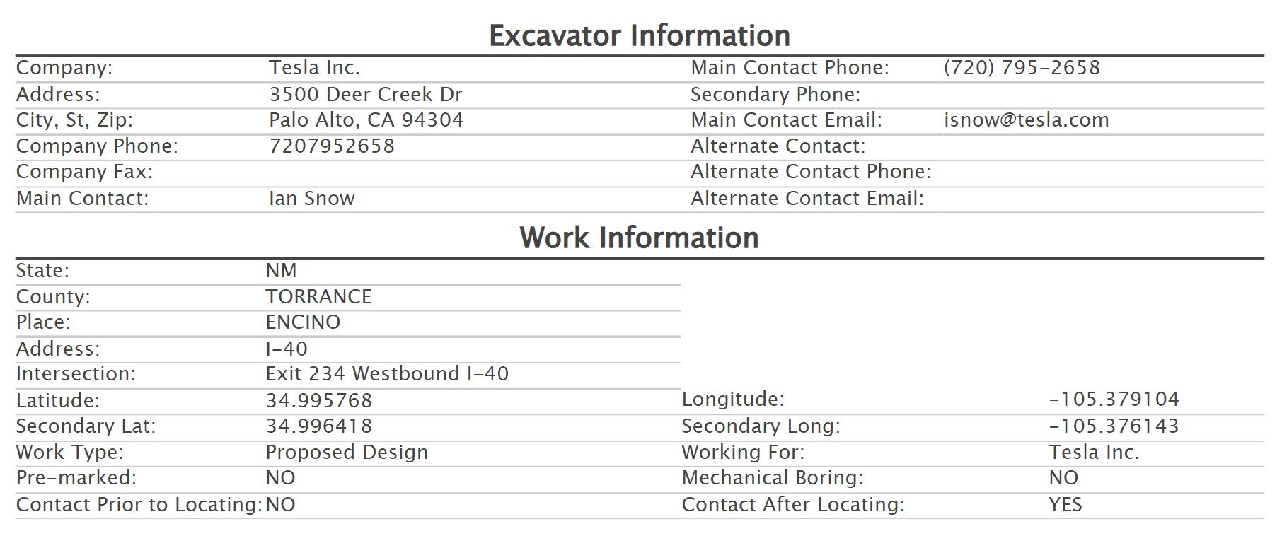
Supercharger - Encino, NM
Marco found a filing for Superchargers at the Bowlin's Flying C Ranch/Exxon located at Exit 234, I-40, Encino, NM 88321. https://goo.gl/maps/4PfVzU8U1CaXNhHu8 Exit 234, I-40, Encino, NM 88321 @corywright @Big Earl @Chuq
teslamotorsclub.com
Also, added a missing pathetic splitter to the Open table. On I-40 Albuquerque - Louisiana Blvd NE, NM split 116.8 miles, 3.7 miles from Albuquerque, NM, 114.5 miles to Santa Rosa, NM.
Interstates standards or not, it's the only road connection...
If you can find me the actual start and end points of the Interstates I'll record them.
They're unsigned, not on OSM or Google Maps and Wikipedia doesn't have the details, unlike other Interstates and US Numbered Highways..
For example A-1 goes from somewhere in Anchorage to Alcan Border, with a route on AK-1 and then some AK-2 east from Tok.
A-2 is Tok to Fairbanks, so is probably just part of AK-2, although it could be some of
A-3 is Soldotna to Anchorage, which is a chunk of AK-1.
A-4 is Gateway (near Palmer), AK to Fairbanks, AK and seems to match with AK-3.
I think it's just easier to deal with them as numbered state highways.
Splitter! On I-69 Washington, IN splits 103.5 miles, 47.7 miles from Haubstadt - Ruffian Way, IN, 57.7 miles to Bloomington, IN.
It's also a significant hole-filler, being a splitter on US-50 or US-150.
 teslamotorsclub.com
It's also a significant hole-filler, being a splitter on US-50 or US-150.
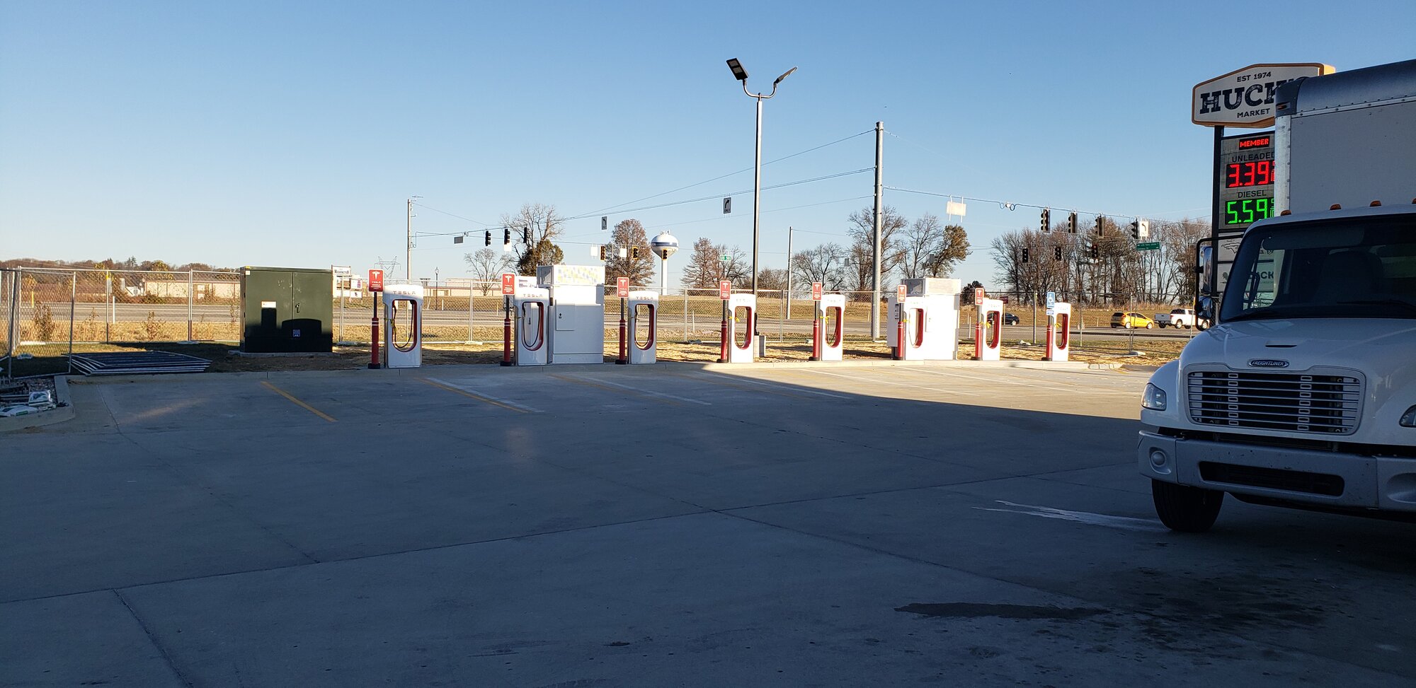
Supercharger- Washington, IN
On a road trip for work and saw this at the Hucks at 1 Gateway Dr, Washington, IN 47501. Searched for a reported SC at this location but nothing found. Adding this post, remove if a duplicate.
teslamotorsclub.com