Welcome to Tesla Motors Club
Discuss Tesla's Model S, Model 3, Model X, Model Y, Cybertruck, Roadster and More.
Register

Lowest Wh/mi challenge

This site may earn commission on affiliate links.
Figured I'd make a fun little game with the Tesla Regen system.
What is the lowest Wh/mi you have ever gotten? No prize or anything just bragging rights :)

Rules is it has to be on the setting for "last 30 miles".

Because when it's set to last 5 or 15 miles it's pretty easy to get crazy high numbers on a little gopher mound of a hill. Besides last 30 is a more accurate measurement anyway so it should be the one used by default.

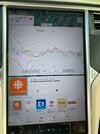
So my entry, is this one at -45Wh/mi I got this going down the Carson pass in California.

IMG_20190807_090158.jpg
 
  • Like
Reactions: VikH and uspearls
I know this doesn't count since it's just for the past 10 km, but I think it's the lowest I've ever had. -37 Wh/km is -59.5 Wh/mi.
It was also in freezing temperatures (easily below 0F).
Pretty cool how the car didn't consume any energy at all in the last 5 km, and instead generated over half a kWh of energy.


IMG_4401.JPG
 
Just got -220 kWh/mi over 5 miles this past weekend, the 15 mile average was decent too but no where near that low. 30 mile is a lot harder to accomplish, good job on the -45 over that mileage. :D

View attachment 580956

I'm surprised people have it on last 5 miles. It's not very accurate of your driving habits at such a small sample size.
Like yesterday I drove down a small hill to work and I changed from last 30 to last 5 and went from 310 avg to -197 avg. Just because this tiny little hill that was 4 miles long. o_O
 
  • Like
Reactions: VikH
A few years ago someone posted their Wh/Mi coming down the big volcano on the Island of Hawaii. It was something like -250.
That's @Polly Wog going down 10,000 foot Haleakala on Maui:


-287 Wh/mile over 30 miles and -268 Wh/mile for 35.1 miles is one reported trip. There aren't any mountains or roads in other states that can come close to that elevation drop in that short a distance.
 
  • Like
Reactions: Polly Wog
My best is -19 Wh/mile for 33 miles descending from Mt. Wilson a net 5,000 feet to my home in Glendale. But the last 10 miles of that is freeway plus about a 400 foot climb to my house. I always gain ~15 rated miles descending from Mt. Baldy or the Angeles Crest to the L.A. Basin. I'll have to check the Wh/mile on one of those drives sometime.

I agree Haleakala is a best case scenario and I can't think of anyplace in the lower 48 that could match it for a descent by road.
 
There are some steep mountains in the west. I think 13,000 ft elevation is the highest in Colorado. There are some roads in Oregon that get above 5000 ft. I think one goes to about 10,000.
We have two (of more than 50) mountains over 14,000 feet (called "fourteeners" here) with roads to the top: Mount Evans and Pikes Peak. The problem is that the rest of the state is so high that those mountains don't stand out as much as Haleakala on Maui. The lowest elevation in Colorado is 3315 feet but it is near the border with Kansas and Nebraska, more than 200 miles from either mountain peak with a road to the top.

Sea level rise won't be affecting Colorado anytime soon... ;)
 
Last edited:
We have two (of more than 50) mountains over 14,000 feet (called "fourteeners" here) with roads to the top: Mount Evans and Pikes Peak. The problem is that the rest of the state is so high that those mountains don't stand out as much as Haleakala on Maui. The lowest elevation in Colorado is 3315 feet but it is near the border with Kansas and Nebraska, more than 200 miles from either mountain peak with a road to the top.

Sea level rise won't be affecting Colorado anytime soon... ;)

There is a road that goes from near sea level at the Columbia River to 6000 ft on Mt Hood (Timberline Lodge) in a relatively short drive, though I think it's about 40 miles. I believe Timberline Lodge to Sandy, OR is about 30 miles. Sandy is about 1000 ft.

Mt Adams is also close to the river, but I don't think there are any roads that go up all that far on that mountain.

Volcanoes are a good bet if you're trying to get quick elevation changes.
8000 feet is about the best we can do over 30 miles in Colorado and, perhaps, anywhere else in the Lower 48:

Pikes Peak to Colorado Springs-profile.png


My San Juan Mountains are fairly rugged and high profile, but there are no roads to the top of the fourteeners here:

Mountain vista from Inspiration Point 1054-56sf 5-14-14.jpg

Part of the San Juan Mountains, including Mt. Sneffels, from Inspiration Point on Log Hill Mesa, eleven miles away.
 
8000 feet is about the best we can do over 30 miles in Colorado and, perhaps, anywhere else in the Lower 48:
My San Juan Mountains are fairly rugged and high profile, but there are no roads to the top of the fourteeners here:
In California we also have two fourteeners which I've hiked one (Shasta) there is no roads to anything but the base of either. But that is up north and south central of the state, this is just an area where i grew up near Tahoe.
i just did a rough waypoint maker since i couldn't totally figure out that site but its a damn cool looking graph. I could do better but i didn't wanna hold up traffic trying not to use the throttle to coast over a few small hills.

20210406134907-32168-profile.png
 
^ I tried to figure out if it would be possible to drive from a high altitude in California to Death Valley but the roads just aren't all that high and it is a long way from the mountain passes to Death Valley. The trick is to cram a big descent into 30 miles!

The Salton Sea also gets below sea level, but it's even further from any mountains.

The Pike's Peak descent is probably one of the best drops in North America. It's probably why they have the hill climb contest there every year. It's a real challenge both from engineering and driving to climb that peak.

The 6000 feet at Timberline Lodge is probably the highest I've ever been and I really felt the altitude there. It must be pretty intense at Pike's Peak. In aircraft they usually go on oxygen around 10,000 feet.
 
That's @Polly Wog going down 10,000 foot Haleakala on Maui:


-287 Wh/mile over 30 miles and -268 Wh/mile for 35.1 miles is one reported trip. There aren't any mountains or roads in other states that can come close to that elevation drop in that short a distance.
Thanks for the mention, @dgpcolorado! I still haven't seen anybody post anything close to my "unofficial" record of -287 wh/mi over 30 miles, but I think if anybody has a chance, it might be on the Big Island descending from the top of Mauna Kea and heading towards Kona.