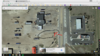
Brush, CO
Interstates: I-76
US Numbered Highways (<=5 mi): US-6, US-34
I-76:
From: Start (I-70, Arvada, CO): 90 miles
To: End (I-80, near Big Springs, NE): 100 miles
Diversion: 3 miles*
From: Silverthorne, CO (I-70, I-76): 154 miles
To: Ogallala, NE (I-76, I-80)
From: Loveland, CO (US-34, I-76): 79.4 miles
To: Limon, CO (CO-71): 76.4 miles
From: Denver, CO (CO-E-470, I-76): 86.7 miles
From: Cheyenne, WY (US-85, US-34, I-76): 117 miles
To: Goodland, KS (US-34, CO-63, US-36, CO-59, I-70): 164 miles
This will "complete" I-76, breaking up the length into two segments easy segments.
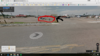
* Google mapping on Supercharge.info suggests that you have to do a loop to get to and from the Supercharger heading East along I-76, which creates the large diversion. But I'm not sure that that's correct. According to Streetview's pictures and the I-76 Wikipedia entry, it's a cloverleaf. Can anyone confirm that it's a cloverleaf with an easy off-and-on?