


I was looking at 17.44 firmware yesterday and discovered they added code to enable vector maps from Google Maps. Disabled by default.
The looks are mostly the same, but it allows you to zoom quite a bit more and friends that tried it in-motion report much smoother operation + higher detailed maps on the big screen.
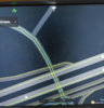
I just took a couple of screenshots to show you how much you cannot tell the difference between the two unless closely looking")
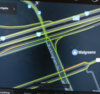
Before enabling the vector maps, max zoom at some random location:

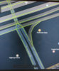
Now the same place with vector maps enabled, zoomed all the way in:


The looks are mostly the same, but it allows you to zoom quite a bit more and friends that tried it in-motion report much smoother operation + higher detailed maps on the big screen.
I just took a couple of screenshots to show you how much you cannot tell the difference between the two unless closely looking
Before enabling the vector maps, max zoom at some random location:
Now the same place with vector maps enabled, zoomed all the way in:
Attachments
Last edited by a moderator: