Welcome to Tesla Motors Club
Discuss Tesla's Model S, Model 3, Model X, Model Y, Cybertruck, Roadster and More.
Register

Western Canada Superchargers

This site may earn commission on affiliate links.
Ran out of charge tonight and needed a flat bed. Left kamloops for home with 271 and ran out of charge 5 km from hope sc

Temperature was -20 over the pass

I did 125 km/h from kamloops to merrit and left merrit with 140km. Avg speed over coq was 100km. Did 120 until the top of Larson hill then started slowing down until 80 on the far side of the coquihalla.

$200 tow
So - as a result of the Provinces Speed Review - you got nailed with a $200 Tow!
Wikipedia: Effective July 2, 2014, Ministry of Transport and Infrastructure increased the speed limit of Coquihalla Highway from 110 km/h to 120 km/h after conducting engineering assessment and province-wide speed review

So - you were 'Only' going 5 Kph over the 'New' Posted Speed Limit, but you still were going 15 Kph over the previous Speed Limit - and - as you say - Temps were -20 (I am guessing - that was - Celsius?), but it seems to me - driving the old speed limit of 110 tops, and maybe 100 Kph in the winter - would both be safer, and Cheaper, if you did not want to stop in Merritt for Level 2's - Either at Wagon West Travel Plaza, or one of the down down locations - Merritt Visitor Info Centre, Merritt Civic Centre, or Merritt Chamber of Commerce.

I had experiences in a High School Conversion running out of Juice in the Toronto Area, on the Freeway, and being offered a tow (for $20), but - with the old Lead Acid EV Conversion - a patient wait, drive, wait, cycle got me to the next exit and a chance to charge enough at a store ($5) to make it home - before EV Charging Existed! Not Likely an option with Lithium!

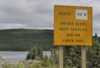
This whole Story is another great reason to push for at least a 30 Amp Level 2 - if not a 60 Amp or higher station to be installed at the Coquihalla Toll Booth Rest Area - currently just a wall plug, with extension cord possibly needed!

This is also a Lesson in Patience, Planning, and Preparation: You don't mess with the 'Coquihalla' lightly!

Left kamloops for home with 271 and ran out of charge 5 km from hope sc
Hmmm - this seems like 74 Kms Short of the Rated Range of the 60 kWh Model S, and way lot less (190 Kms) than a full range charge for the 85 kWh version - Per Canadian Specs.

And - I wonder - was not a 'Fill up' at the Kamloops Supercharger an Option at this point?
 
Last edited:
Coquihalla

This Story Also reminds me of Desert Driving, like From Salt Lake towards Reno - and the signs seen in movies, like -

'Last Gas for 200 Miles! Fill up Now! [/B]
DSC_0565.1.JPG

- or something like that! Maybe the Coquihalla needs a similar EV Sign when leaving Merritt?

In Flight Refueling - For EV's is not yet a working option!
View attachment 67714

This Sign is not a good one to miss, even in such nice weather and flat roads:
usnv54817.jpeg


OK - so does the Tesla have an on-board Planning GPS / Nav option to help avoid situations like this one?
 
Ran out of charge tonight and needed a flat bed. Left kamloops for home with 271 and ran out of charge 5 km from hope sc

Temperature was -20 over the pass

I did 125 km/h from kamloops to merrit and left merrit with 140km. Avg speed over coq was 100km. Did 120 until the top of Larson hill then started slowing down until 80 on the far side of the coquihalla.

$200 tow

Was your tow truck driver one of the people in the link below? It would be funny to see you as one of the segments on the show being taken to the new Superchargers in Hope...

Highway Thru Hell

I like watching that show. The #1, 3 and 5 highways really can be hell in the winter. I drive the #3 a lot in the winter to my cabin and I have seen some pretty bad accidents.
 
Last edited:
Drove back through Canmore today in my ICE vehicle but decided to see how things were progressing in Canmore. See photos from this afternoon below. Parking for 4 Teslas but the spots are right in the middle of a hotel parking lot - very high likelihood of being ICE'd.

- - - Updated - - -

Also, I noticed the location on my Supercharger.info browser (I was on iPhone) was incorrect. The correct location is here:
 

Attachments

  • IMG_0603.JPG
    IMG_0603.JPG
    213.4 KB · Views: 437
  • IMG_0604.JPG
    IMG_0604.JPG
    131.5 KB · Views: 427
  • IMG_0606.JPG
    IMG_0606.JPG
    272.3 KB · Views: 432
  • IMG_0605.JPG
    IMG_0605.JPG
    304.1 KB · Views: 423
  • IMG_0607.JPG
    IMG_0607.JPG
    148.2 KB · Views: 434
  • IMG_0608.JPG
    IMG_0608.JPG
    278.3 KB · Views: 418
  • 2015-01-02_20-52-46.jpg
    2015-01-02_20-52-46.jpg
    142.1 KB · Views: 427
3s-a-charm, your map of Canmore shows Bow Valley Trail and Mountain Ave as one way streets. I was driving the opposite way on Bow Valley Trail just last Sunday and nobody was flashing their lights or honking their horns at me. Did I miss something?
Right... sorry! Bow Valley Trail is 2-way. I was highlighting the one-way street at Mountain Ave as it makes access to the Supercharger a little tricky - especially as access is only available off Mountain.
 
Ran out of charge tonight and needed a flat bed. Left kamloops for home with 271 and ran out of charge 5 km from hope sc. Temperature was -20 over the pass
I did 125 km/h from kamloops to merrit and left merrit with 140km. Avg speed over coq was 100km. Did 120 until the top of Larson hill then started slowing down until 80 on the far side of the coquihalla.
$200 tow

Hi,

I don't know whether you talk about Typical Range or Rated Range and whether it was a Model S 60 or 85.

When driving in Germany (my home) with my Model S 85 Signature, I add 50 km on top of the Typical Tange display to be on the safe side around 0 degrees Celsius with rain. And I only drive 120 km/h on German Autobahns (a lot more brake and accelerate than in BC, since trucks only go 95 and all the others at different speeds from 100 to 230, which makes passing a brake first and then accelerate issue).

So I guess at minus 20 degrees Celsius at 125 km/h and through steep mountain roads like the Coquihalla you need to add at least another 50 km Typical Range to be used up.

Since Kamploops - Hope is 199 km according to supercharge.info, your 271 km were not enough safety to start with when it was Typical Range (you should have started with 300) and far too little range to plan with if it was Rated Range.

Cheers

Frank, currently in Vancouver
 
Last edited:
I'll add a bit of clarity Frank.

a few weekend before I had made it from Merritt to home with 108 km leaving merrit (I know it looks like the distance is further, BUT, you gain 10 km rang going down from the summit AND traverse about 25 km during that descent).

Based on that info, and the descent from Kamloops into Merrit, I would have thought leaving with the charge I did would have worked. Now, based on the charging question thingy (how far can I go page) on Tesla Motors, driving at -10, night, with heater (obviously with kids and it was more than -10), at 120km (the speed limit) only let's you go 200 ish km. However, Tesla has said that super chargers are placed a distance apart that would allow a 60kw battery (which is what I drive), to make it between them with a full charge.

Today I returned from merrit, leaving town with 191km, -5 avg temperatur, and avg speed of 105km/hour (snowy day), fully loaded and made it into hope with 20km remaining. So that means that had I driven the speed limit, I would have needed in the area of 200-215 km to make it... ok, fine. BUT, the distance from Merrit to Kamloops is 85km (again 120km and mountains etc). There is no way, even leaving Kamloops with a full-charge on a wintery day that you could make it.

COMPOUND THIS... with how often you get half way down the coq and it's closed because of an accident or other major event... this would mean a) you sit there and let your batter run out while keeping you warm, b) you call a tow truck and tell them to meet you somewhere on the way back cause you aint gonna make it off the coq :)

I KNOW... I left with less charge then I needed. But how can you really know without tons of experience. I mean, my distance to sc said 203km... so that means technically even if someone left with an extra 50km as you suggest, they wouldn't make it... 100km extra? nope. Your stuck guessing. I think this shows how the "how much charge do I need app IN THE CAR" is needed, and b) how badly a SC in Merritt is needed.

Another piece of evidence is that another car, an 85kw (See above) drove from Kelowna to Hope and almost didn't make it... that's only 40km distance difference... so again. Having a SC in Merritt would help.

One last tidbit of interest. Turns out my air suspension wasn't auto-lowering, hence my even worse mileage that night. I wondered why it was so bad (taking every thing else into account) and voila... no lowering suspension on the hwy. Today's numbers FYI were when I manually lowered the suspension over the passes so they are more accurate.

WHY I POST THIS: I believe in community knowledge share and hope my travels and experiences over the passes help other current and future owners. This will get better with more SC infrastructure. But for now, we help each other with sharing what we see/experience. I'm not beating up on Tesla (not that I would need to defend myself if I were lol )
 
Last edited:
Thanks for your clarification nleggatt,


Since I've been driving solely electric since 2006 the most important thing I've learned is: you can never be too cautious with your guesses on range of an EV. Always start with the highest possible charge for conditions / routes you didn't drive yet, no matter what other people or guess-o-meters say. The first time in extreme conditions you still have to be careful, even if you've driven the route before in different conditions.


I learned this the hard way, like you, only with the cars back then (TWIKE or i-MiEV for instance) it wasn't hundreds of kilometers from home. :)


Sent from my HUAWEI P7-L10 using Forum Fiend v1.3.
 
One last tidbit of interest. Turns out my air suspension wasn't auto-lowering, hence my even worse mileage that night.

Yeah, I've had auto-lowering switch itself off. It's happened when I've had the car in for service. I don't think service actually switched it off (at least I hope not), but they did upgrade the firmware and it's not unheard-of for settings to occasionally vanish during an upgrade. (I used to lose my mirror auto-tilt every time the firmware was upgraded - they seem to have fixed that.)
 
So it looks like they'll be connecting eastern and western Canada, but through the USA. And also connecting Winnipeg into the USA route.

Hmm... Winnipeg Superchargers... does that count as West? Or do we have to make a new thread for central? :biggrin:
 
Good find @Riverbrick! That is awesome! I have attached a blow up of the 2016 map for simplicity. Looks like BC adds Vancouver, Merrit, & Kelowna. AB adds Edmonton, Lethbridge, then south to Montana via Shelby and Great Falls. MB adds Winnepeg then south through N Dakota via Pembina.
216W.jpg
 
Last edited:
Hmm... Winnipeg Superchargers... does that count as West? Or do we have to make a new thread for central? :biggrin:

Well, according to both the CFL and the NHL, Winnipeg is "west". So I guess that's definitive!

FYI, as I grew up in Kenora, ON and our extended family was in Tdot area, I'll point out that it's definitely faster/shorter to drive south into Minnesota, then east along northern Wisconsin, then over the Mackinac and cross at Sarnia/Port Huron. Driving north of Superior then south on 69/400 is longer ... and a lot more treacherous in winter.