I don't know about "must see" but I think there have been a number of good suggestions from others above in my "neighborhood" here in the Four Corners area. So, some favorites of mine, in no particular order:
Colorado National Monument CO:
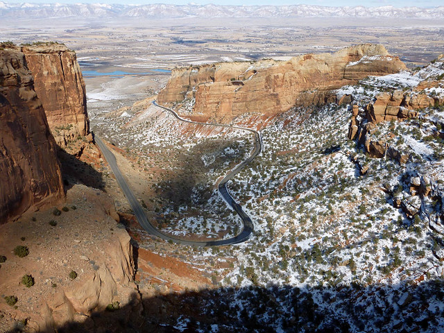
^ The road from the Fruita (west) entrance to Colorado National Monument
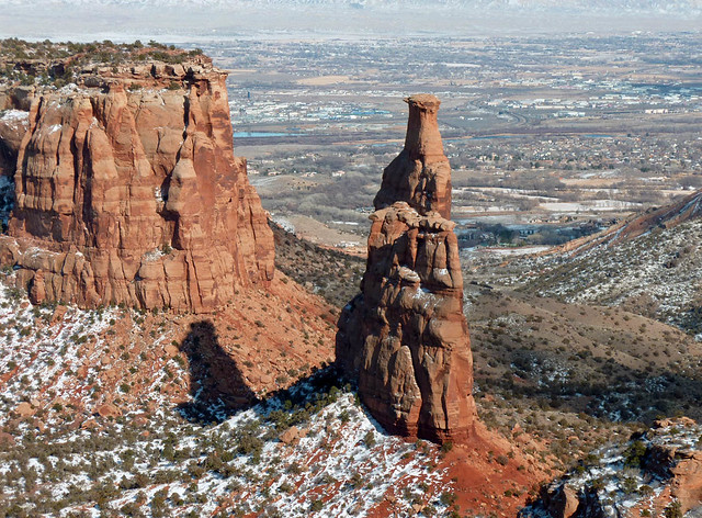
^ Independence Monument
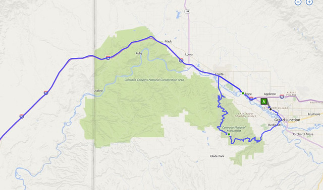
^ Map showing the route through Colorado National Monument. Notes:
The route roughly parallels I-70 and is very easy to access from the Grand Junction CO Supercharger Station. The road through the Monument is longer, slow, has considerable elevation change of about 2000 feet (600 m), and is very scenic.
https://www.nps.gov/colm/planyourvisit/upload/COLM_Map.pdf
Also of note: at exit 2 near the Utah border is "Trail Through TIme", a short trail right next to the freeway through an area of dinosaur fossils. Not the least bit scenic but if you want to see real dinosaur fossils
in situ it is worth a visit. (I helped build part of the trail many years ago with Volunteers for Outdoor Colorado.)
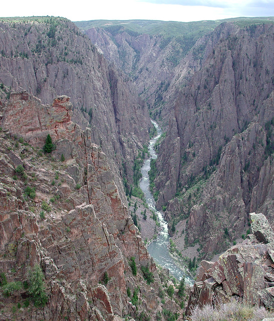
Black Canyon of the Gunnison National Park:
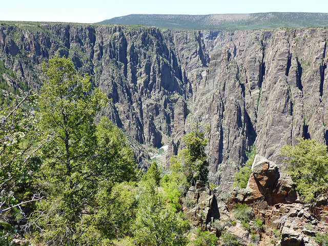
^ Black Canyon of the Gunnison. Notes: A bit off the beaten track but it can be accessed from the Grand Junction CO Supercharger Station. One of the campground loops has 14-50 outlets and there is an L2 charge station in nearby Montrose CO. The canyon is more than 1800 feet deep and less than a thousand feet across at the top at one point. Lots of scenic overlooks with views down into the canyon.
https://www.nps.gov/blca/planyourvisit/upload/BLCAmap_2013_w-masthead.pdf
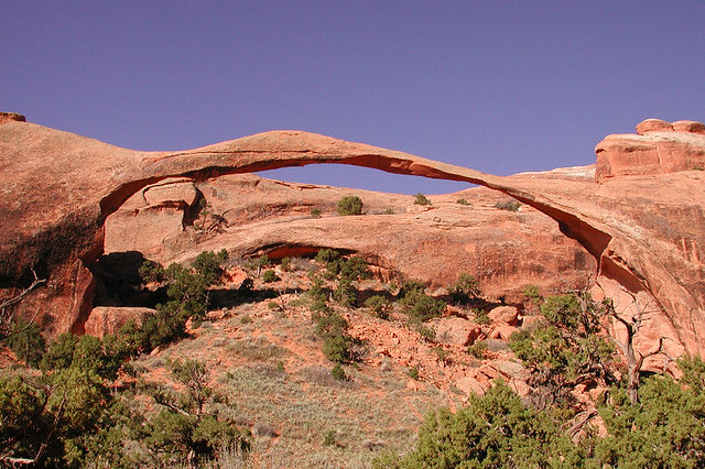
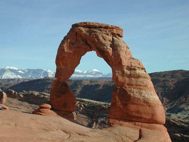
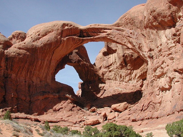
Arches National Park UT:
^ Landscape Arch
^ Delicate Arch (Interesting bit of trivia: the names of Delicate and Landscape Arches were mixed up by an early mapmaker and the wrong names are used to this day.)
^ Double Arch (Can you see the single person I included in the photo for a size reference?) I have many more pictures from Arches but these will do for a start.
Arches National Park is a couple of miles from the Moab UT Supercharger Station. This is my favorite national park. One caution: the campground and much of the access road will be closed for construction from March 2017 to mid October 2017, so some parts of the park, such as Landscape Arch, may not be accessible. However I would expect that the main "Windows" section of the park will remain open. Check before you go.
https://www.nps.gov/arch/planyourvisit/upload/ARCHmap.pdf
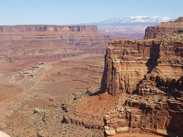
Canyonlands National Park, Island in the Sky District UT:
The Island in the Sky District of Canyonlands is accessed from US 191 north of Moab. The drive into the park is quite scenic. This district is the best for touring by car and checking out the overlooks. The Needles District is the best for serious hiking. One big caveat: the vistas are long distance and air pollution from California, Arizona, and Nevada usually causes a haze that makes the distant views less impressive. If you happen to hit a clear day Island in the Sky is very impressive. The same is true for Grand Canyon. (If we can just get rid of all ICE cars and coal power that would help clear the air in my neighborhood! I expect that I'm too old to ever see it.)
https://www.nps.gov/cany/planyourvisit/upload/tripmap.pdf
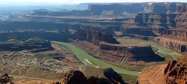
Dead Horse Point State Park (Utah):
^ Colorado River from Dead Horse Point (see what I mean about the haze I mentioned above?)
Dead Horse Point State Park is located adjacent to the Island in the Sky District of Canyonlands. It has the best view of the Colorado River from 2000 feet above. Good for easy hiking, bicycles, and car overlooks. The campground has 14-50 RV outlets at each campsite.
Hiking At Dead Horse Point | Utah State Parks
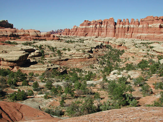
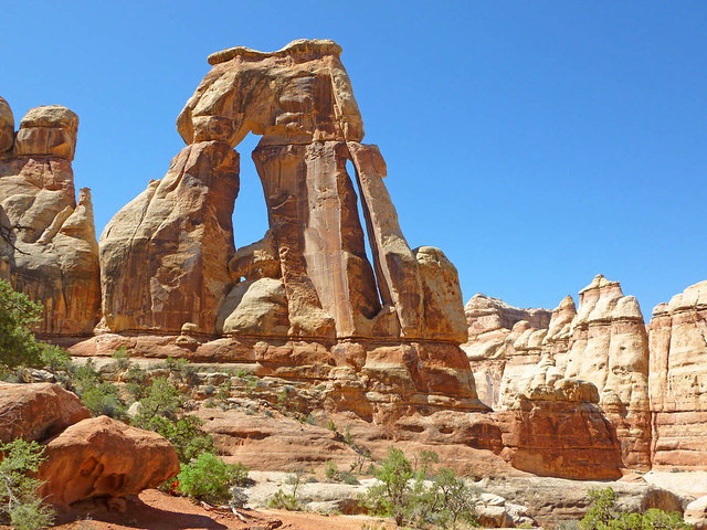
Canyonlands National Park, The Needles District UT:
^ Wideangle view of Elephant Canyon
^ Druid Arch, an eleven mile (round trip) hike over slickrock and sandy washes.
Notes: The Needles District is best experienced via its many hiking trails. Because the scenery is close and dramatic it doesn't suffer from the air pollution issues of Island in the Sky. The access is from US 191 between the Moab UT and Blanding UT Supercharger Stations. The access road goes by "Newspaper Rock" a good example of Native American petroglyphs.
https://www.nps.gov/cany/planyourvisit/upload/NeedlesTrailsandRoads.pdf
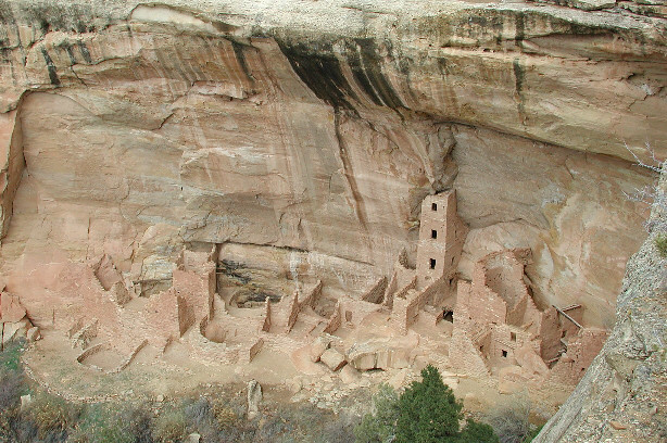
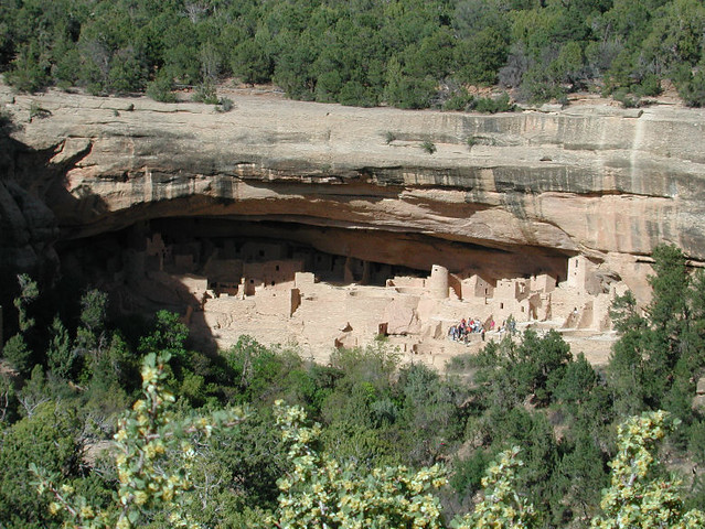
Mesa Verde National Park CO:
^ Square Tower House
^ Cliff Palace
Mesa Verde National Park is located between the Blanding UT and Farmington NM Supercharger Stations. The access road is long so charging at the campground (TT-30) or an RV park might be helpful, depending on your car's range. There is Tesla destination charging at Far Point Lodge inside the park. The park is a great way to get a look at thousand year old ruins from early Puebloan settlements. Do check out the little museum which has authentic artifacts recovered from the ruins.
https://www.nps.gov/meve/planyourvisit/upload/mevemap2016_8x11.pdf
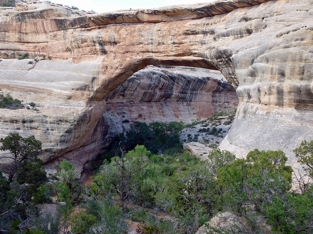
Natural Bridges National Monument UT:
^ Sipapu Bridge, one of three bridges in Natural Bridges National Monument
Natural Bridges National Monument is off of Utah SH 95 and is easily accessed from the Blanding UT Supercharger Station (the highway has some twisties that are fun to take at speed in a Tesla if there is no traffic in front). That highway is quite scenic and remote, from Blanding to Hanksville UT (access to Capitol Reef National Park). The Monument has several car accessed overlooks but hiking to the bridges, or between them along the wash, provides the best views.
Other places of note in this area are
Petrified Forest National Park off of I-40 near Holbrook AZ and
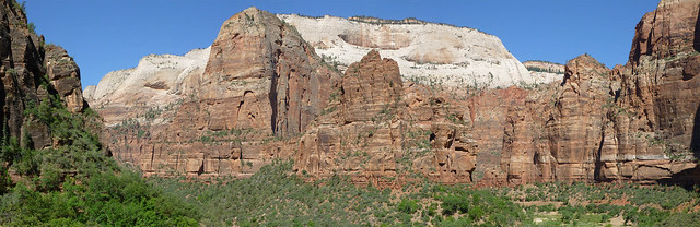
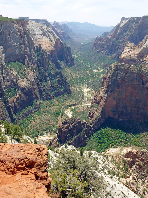
Zion National Park accessed from I-15 near St. George UT.
^ Panorama of canyon walls, Zion Canyon
^ View of Zion Canyon from Observation Point, an eight mile hike with 2000+ feet of elevation gain.