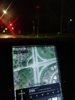
Since I find myself looking at the nav all the time, I find myself trying to see how helpful the traffic conditions are. I see yellow or red lines (except Hawaii in rush hour, the whole island is red lines) at different intersections. I'm assuming it's supposed to be traffic , but it can be midnight, with no one else on the road. Are these supposed to be real time or estimates based on collected data over a long period of time?


-
Want to remove ads? Register an account and login to see fewer ads, and become a Supporting Member to remove almost all ads.
Traffic accuracy
- Thread starter kalikikopa
- Start date