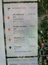
I was sitting in the car in Boulder, Colorado and I asked it to plan a route to Tusayan, AZ near the Grand Canyon. It gave me the attached route. It seems a tad optimistic as this route crosses one of the biggest L3 charging “deserts” in the lower 48: the Navajo Nation, between Blanding, UT and Tusayan, AZ - 256 miles with elevation gain.
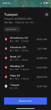
While sitting in the car I used the Tesla mobile app to plan the exact same trip. It gave me a less optimistic route with 2 additional charging stops including an 80 mile detour around the charging “desert.”
Any ideas why the mobile app would be more conservative than the car?
While sitting in the car I used the Tesla mobile app to plan the exact same trip. It gave me a less optimistic route with 2 additional charging stops including an 80 mile detour around the charging “desert.”
Any ideas why the mobile app would be more conservative than the car?