Welcome to the world of probability.Only 5% chance now for hurricane force winds for Palm Beach and only 2" of rain predicted. We get more than 2" of rain on any given summer thunderstorm. What a crazy swing in predictions.
79% chance of Tropical Storm winds.
View attachment 246609 View attachment 246610 View attachment 246608


Welcome to Tesla Motors Club
Discuss Tesla's Model S, Model 3, Model X, Model Y, Cybertruck, Roadster and More.
Register
Install the app
How to install the app on iOS
You can install our site as a web app on your iOS device by utilizing the Add to Home Screen feature in Safari. Please see this thread for more details on this.
Note: This feature may not be available in some browsers.
-
Want to remove ads? Register an account and login to see fewer ads, and become a Supporting Member to remove almost all ads.
You are using an out of date browser. It may not display this or other websites correctly.
You should upgrade or use an alternative browser.
You should upgrade or use an alternative browser.
Hurricane Irma
- Thread starter DiamondHands
- Start date
RedFiveZero
Member
Go to your car's navigation system map and scroll into the particular Supercharger Station that you are interested in. Put your finger on the icon and the system will provide the status of how many stalls are available with a lag of 5 minutes.
Is there anyway to obtain supercharger status other than the in car navigation system?
For example, I'm taking a break from driving and want to browse various superchargers with my iPhone while I'm in a coffee house or restaurant?
As I explained in posting #115:Is there anyway to obtain supercharger status other than the in car navigation system?
For example, I'm taking a break from driving and want to browse various superchargers with my iPhone while I'm in a coffee house or restaurant?
Additional information:
Tesla informs me that if you have any difficulties interpreting your navigation system, or if for some reason the Supercharger status isn't showing in your car, call Roadside Assistance at 877-79-TESLA.
Roadside Assistance has access to Supercharger vital signs. I am informed that they are keeping a very close eye on them and will communicate any concerns to us appropriately.
There is no other online status available to us besides the navigation system.
Larry
Last edited:
> Yet electricity is still readily available.
Yesterday it was reported the 2 FL nuclear power plants will begin to shut down in anticipation. FWIW.
--
Thankfully, demand drops as people leave (and, unfortunately, drops a lot if there's a lot of damage). Here was the Texas forecast pre-Harvey:
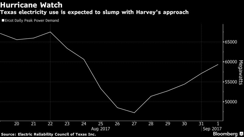
Because the damage was so severe, I expect that it bottomed out even deeper and has been recovering significantly slower (but can't find any more recent graphs post-storm).
Forgot to post the 06z GFS when it came in:

It's nice to finally have some consistency with the GFS and ECMWF ensemble members. While there's still uncertainty about intensity and whether it'll be just offshore or just onshore (and by how much), either way, it's a "go up the west coast" storm. And regardless of the peak winds, she'll be packing some significant surge.
The intensity and track forecasts will get a lot easier once she stops interacting so much with Cuba.
Last edited:
Only 5% chance now for hurricane force winds for Palm Beach and only 2" of rain predicted. We get more than 2" of rain on any given summer thunderstorm. What a crazy swing in predictions.
79% chance of Tropical Storm winds.
Wow, what a fortuitous change of forecast for our neck of the woods!
... for Palm Beach and only 2" of rain predicted. We get more than 2" of rain on any given summer thunderstorm. What a crazy swing in predictions.View attachment 246610
Your weather station is messing up something fiercely. Less than 0,5" of rain on the side of Florida that's being hit by a hurricane (west side)? Um, no.
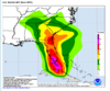
Here's the last GFS total precipitation graph through 6 PM on Monday:

Here's a sample 24h precipitation graph:

Obviously it depends on which 24 hours you select. But expect to get wet.
Last edited:
West Palm Beach is on the Atlantic coast of Florida
Please view the person's attachment again. It shows even less rain on the Gulf side (0.5" near Tampa).
It's not a graph for Irma; it's probably a graph for for the day in which it was broadcast.
geneclean55
Active Member
Sure, but the problem with those images are that they stop around Boca Raton however the state continues for about 80 miles south from that point. And those southern areas are where the hurricane will hit first and where accumulation will be most by midday tomorrow.
Sure, but the problem with those images are that they stop around Boca Raton however the state continues for about 80 miles south from that point. And those southern areas are where the hurricane will hit first and where accumulation will be most by midday tomorrow.
No, the problem with the rainfall image is that it's not a rainfall image for Irma at all. It's a rainfall image for the amount of rain to expect starting today but terminating before Irma arrives.
Last edited:
No
Did you even look at the image? It says rainfall accumulation Sunday 12.30.
Then it's not the rainfall totals for Irma. I'm looking at (and posted for you) the GFS right now. Or just use some basic logic: a major hurricane is not going to sweep up the west coast and dump only half an inch of rain in Tampa. Seriously people....
Furthermore, that is the forecast for only 24-hours starting today. Again, check the GFS yourselves:

The exact details of the map depend on what time period you choose, but note - less rain in Tampa? Check. Good rain in the southeast? Check. Moderate range in Vero Beach? Check. A "gap" at Port St. Lucie? Check. That's the forecast for today, not Irma. See the giant blob to the south-southeast? 20 inches of rain per day? That's Irma.
Last edited:
geneclean55
Active Member
Who said that?
I don't think you have a good understanding of geographical distances in Florida. How far up the coast do you think Tampa is? Total rainfall in Tampa will be more than 0.5 inches once the hurricane has passed through, but not necessarily by lunchtime tomorrow.
But anyway, what does that have to do with West Palm Beach?
People here are acting like West Palm Beach is expected to only get 2" of rain from Irma because of that graphic. E.g.:
I'm simply pointing out that this is the amount of rain that is to accumulate from today to before Irma arrives, not the amount of rain that is to accumulate from Irma total. As for what that has to do with West Palm Beach, the amount of rain forecast for West Palm Beach is 4-10", depending on what forecast you look at and what track Irma takes. Not 2".
Not that it wouldn't be lovely if you guys only got 2"")
Only 5% chance now for hurricane force winds for Palm Beach and only 2" of rain predicted. We get more than 2" of rain on any given summer thunderstorm. What a crazy swing in predictions.
Wow, what a fortuitous change of forecast for our neck of the woods!
I'm simply pointing out that this is the amount of rain that is to accumulate from today to before Irma arrives, not the amount of rain that is to accumulate from Irma total. As for what that has to do with West Palm Beach, the amount of rain forecast for West Palm Beach is 4-10", depending on what forecast you look at and what track Irma takes. Not 2".
Not that it wouldn't be lovely if you guys only got 2"
Last edited:
geneclean55
Active Member
I for one am not disputing that rain will persist for several days over Florida. But you said that the weather station images were incorrect, and had the wrong dates.
Might I suggest that you read very carefully the text at the top of the GFS image that you just posted and then realize the similarity between the two forecasts.
Might I suggest that you read very carefully the text at the top of the GFS image that you just posted and then realize the similarity between the two forecasts.
I for one am not disputing that rain will persist for several days over Florida. But you said that the weather station images were incorrect, and had the wrong dates.
Might I suggest that you read very carefully the text at the top of the GFS image that you just posted and then realize the similarity between the two forecasts.
I posted that graph specifically to show the similarity between the two forecasts. To show that it was the forecast for before Irma arrived.
BTW, I think we've gotten to the point where we're agreeing with each other in a confrontational manner
Key points that I think we're in agreement on:1) Palm Beach will be getting well more than 2"
2) That is the forecast from today until midday tomorrow
3) That forecast ends before Irma arrives and only represents outer bands
Agreed?
Last edited:
gg_got_a_tesla
Model S: VIN 65513, Model 3: VIN 1913
To our long time TMC friends from the west coast of Florida, like @Larry Chanin and @NigelM, not sure you evacuated from the Sarasota area but, wishing you the very best.
EV-lutioin
Active Member
I posted that graph specifically to show the similarity between the two forecasts. To show that it was the forecast for before Irma arrived.
BTW, I think we've gotten to the point where we're agreeing with each other in a confrontational manner
1) Palm Beach will be getting well more than 2"
2) That is the forecast from today until midday tomorrow
3) That forecast ends before Irma arrives and only represents outer bands
Agreed?
I agree with KarenRei, latest NOAA forecast shows east coast of Fl forecast to get 6-20" of rain. This is just a forecast, of course... things may change as the storm progresses.
Attachments
Last edited:
geneclean55
Active Member
I do generally agree.I posted that graph specifically to show the similarity between the two forecasts. To show that it was the forecast for before Irma arrived.
BTW, I think we've gotten to the point where we're agreeing with each other in a confrontational manner
1) Palm Beach will be getting well more than 2"
2) That is the forecast from today until midday tomorrow
3) That forecast ends before Irma arrives and only represents outer bands
Agreed?
Although folks in the Florida keys, or perhaps Naples Florida might disagree with you that the hurricane hasn't officially arrived by midday tomorrow.
Similar threads
- Article
- Replies
- 37
- Views
- 2K
- Replies
- 22
- Views
- 4K
- Replies
- 25
- Views
- 7K