Welcome to Tesla Motors Club
Discuss Tesla's Model S, Model 3, Model X, Model Y, Cybertruck, Roadster and More.
Register

I-40 from NM to Amarillo - wildly fluctuating!

This site may earn commission on affiliate links.
This one's a first for me and I'm wondering if anyone else has seen it on this stretch.

Charged up to almost 100% in Albuquerque because I ate dinner there. Got to Santa Rosa, topped off until it said I'd make it to Amarillo with 15%. Left and noticed it was dropping like crazy and by the time I got to Tucumcari, it was saying I needed to stay below 55. Pulled in and charged until I hit Amarillo with 25% again.

Now here I am 30 miles later and it has gone from estimated 25% remaining to 6%!

I checked the weather and I'm driving with the wind, not against. I've got AP set to 75 (which is the speed limit). It's not too cold, about fifty degrees. But it keeps dropping rapidly. I'm wondering if something about the mountains on this route are throwing it off or something? Never seen this and getting concerned!
 
I've come to the conclusion that the range forecasting is based on a speed of 65 miles per hour and not on whatever speed limits happen to be in effect. That is based on experience with the OKC <-> Sacramento route as well as along the long stretch between Topeka <-> Wichita. Keeping to 65 keeps me pretty much on the Energy app trend (with allowances for headwinds). Once I get past the half-way mark, the overall impact of speeding up lessens and you can get a little cocky...

I originally thought that those highway range predictions were based on some navigation system "knowledge" of the speed limits (in some sense, anyway)... but the match at a steady 65 (in some overall, aggregate sense) is dead on.

2014 pre-AP P85...
 
  • Like
Reactions: JHWJR
I'm in Amarillo , and I've driven ABQ to Amarillo many times.

The prevailing winds are indeed from the west usually, but last night there were thunderstorms and wind squalls all over the region that change direction depending on where the cells are. You can't go by the NWS under those conditions.

You could find a closer weather station on your tesla browser on findu.com and choose weather stations if you want to see a list. (You can search for KC5JIF there to see a regional list for Amarillo; that station's wind is broken but the others are good). URL is Weather Stations Near KC5JIF , then look at the wind direction column.

That being said, I've had the best luck skipping Santa Rosa and charging to 90% capacity at ABQ and get something at Applebees in my S85. At Tucumcari I usually charge to 35% remaining predicted so I can drive at the prevailing speeds, and arrive in Amarillo at 20%.

Returning to ABQ is usually into the wind and uphill, so in order to go full speed I usually stop at both Tucumcari and Santa Rosa but I don't fully charge, only go to predicted 35% remaining charge on the trip planner.
 
Last edited:
Summarizing, in the 'had' column, is the value you would have had if Nav estimate was correct in getting you to Amarillo:
.........................had ........added
ABQ ................+15%
Santa Rosa ... +2%......... 20%
Amarillo .........+6%

Added ~ 35% over wha the Nav said you needed, but arrived with 6%, giving a 29% minimum buffer for you to 'make it' under your driving conditions.
 
This one's a first for me and I'm wondering if anyone else has seen it on this stretch.

Charged up to almost 100% in Albuquerque because I ate dinner there. Got to Santa Rosa, topped off until it said I'd make it to Amarillo with 15%. Left and noticed it was dropping like crazy and by the time I got to Tucumcari, it was saying I needed to stay below 55. Pulled in and charged until I hit Amarillo with 25% again.

Now here I am 30 miles later and it has gone from estimated 25% remaining to 6%!

I checked the weather and I'm driving with the wind, not against. I've got AP set to 75 (which is the speed limit). It's not too cold, about fifty degrees. But it keeps dropping rapidly. I'm wondering if something about the mountains on this route are throwing it off or something? Never seen this and getting concerned!

I've found the nav system's predictions to vary wildly near the beginning of a drive. Part of the problem appears to be that sometimes the predicted elevation is a little out of sync with the real elevation. This can cause the predicted energy remaining at the destination to vary wildly because one minute the car thinks you're using way more energy than it predicted when it thinks you are going downhill when you are really going uphill and then it thinks you are using less energy than predicted when you are really going downhill and it thinks you are going uphill. Here is an example from a trip last December where I was driving at a constant speed with the cruise control and the nav system made major changes to its prediction over a short period of time. The predictions were jumping around even more before I asked my wife to take a few pictures of the nav screen. If you look closely at the last screen, you can see the predicted and observed energy changes due to elevation are a little shifted relative to each other (the trip length appears a little shorter in the last image because we had to stop at a rest area to tend to our toddler and I reset the nav system after the stop).

And as snellern points out, the nav system also seems to start with an assumed speed of around 65 mph which causes problems in places where the real speed limit is 75 or 80 mph. The prediction does improve as the trip progresses and is pretty much dead on after about half of the trip has elapsed. But after getting burned a few times, I usually consult ev trip planner or simply do the distance and elevation math myself to figure out how much to charge before leaving a supercharger.

IMG_5392.JPG
IMG_5395.JPG

IMG_5398.JPG
 
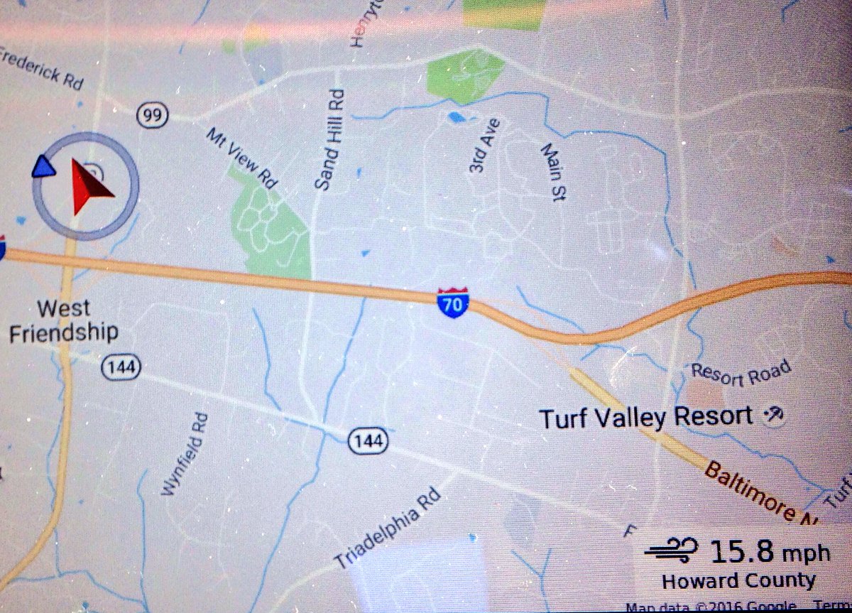
@snellenr I see a red chevron and a blue triangle superimposed on a circle. I'm a former pilot, and might be confused on the symbology. Is the red chevron indicating a wind from the SSE? Is the blue triangle indicating a wind from the WNW? In the pilot world, a wind-indicator is a bit like a wind sock, and looks an awful lot like the red chevron.
 
@snellenr I see a red chevron and a blue triangle superimposed on a circle. I'm a former pilot, and might be confused on the symbology. Is the red chevron indicating a wind from the SSE? Is the blue triangle indicating a wind from the WNW? In the pilot world, a wind-indicator is a bit like a wind sock, and looks an awful lot like the red chevron.
The red chevron is the car, just as in the standard navigation screens. Wind direction is indicated by the blue triangle on the circle around the chevron. In this example, the wind is out of the northwest and is "striking" the left front corner of the car.

The driver in the example appears to have applied some left aileron to correct for the cross wind...
 
  • Funny
Reactions: Missile Toad