Welcome to Tesla Motors Club
Discuss Tesla's Model S, Model 3, Model X, Model Y, Cybertruck, Roadster and More.
Register

Tell me about map updates

This site may earn commission on affiliate links.
Have you looked at your counties GIS system?
That system doesn't show any driveway or speed limit information, at least on the public viewer. Google Maps showed all driveways in the area for at least a decade until last spring, when most of them disappeared. Some addresses still show driveways, but they are the minority now. I don't know for sure that the speed limit data got messed up at the same time since the P85 I had back then doesn't show speed limits and I never use Google Maps for navigation on my phone.
 
That system doesn't show any driveway or speed limit information, at least on the public viewer. Google Maps showed all driveways in the area for at least a decade until last spring, when most of them disappeared. Some addresses still show driveways, but they are the minority now. I don't know for sure that the speed limit data got messed up at the same time since the P85 I had back then doesn't show speed limits and I never use Google Maps for navigation on my phone.
So which maps do you feel are better?
 
So which maps do you feel are better?
Apple Maps is the best I've used in my area. Not only does it show all driveways, it actually navigates me right down my driveway to my garage (not the house or pole barn) and has 3D mapping of all the buildings around and even the tree cover. Google Maps from a couple years back was a close second for navigation. The current Google maps is ok, except I have to tell people with Android phones that my driveway is somewhere else than where they will end up.
 
The main map database gets updated roughly twice a year. Last main update for North America was in December. There's some thinking that stuff gets added to the database from time to time: Whether a turn is right on red or not, for example.
A new map update, 2024.8, just started going out to a bunch of vehicles in North America. (I think you have to be on a 2024.14.x, or higher, version to get the map update.)

I'm also one of the maniacs who subscribes to the $10/month or $100/year online connectivity program. No question: If there's a traffic jam or accident up ahead, the NoA will attempt to route around such a spot, and that includes wandering around local roads for a time. There will be colored overlays on the jammed traffic, you betcha.
Yep, the online routing uses Tesla servers to do the routing, and I think with newer versions the servers monitor your routes and send notices to the car when a better route is available. (Online routing is more likely to know about road closures than if you have the car do offline routing.)

Are you talking about Google maps, you know, the one that the nav system shows?
No, the Tesla navigation system does not use Google map data. Tesla creates and maintains their own navigation system and maps from a variety of sources. (OpenStreetMap, TomTom, etc.)
 
No, the Tesla navigation system does not use Google map data. Tesla creates and maintains their own navigation system and maps from a variety of sources. (OpenStreetMap, TomTom, etc.)
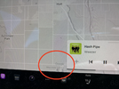
Then how do you explain the Google watermark on the maps in my car?
 

Attachments

  • tempImagesGiOc7.png
    tempImagesGiOc7.png
    932.6 KB · Views: 4
Apple Maps is the best I've used in my area. Not only does it show all driveways, it actually navigates me right down my driveway to my garage (not the house or pole barn) and has 3D mapping of all the buildings around and even the tree cover. Google Maps from a couple years back was a close second for navigation. The current Google maps is ok, except I have to tell people with Android phones that my driveway is somewhere else than where they will end up.
Which is interesting since Apple really hasn't like their own maps over the years. But I'm pretty sure that they buy theirs from somewhere else.