Welcome to Tesla Motors Club
Discuss Tesla's Model S, Model 3, Model X, Model Y, Cybertruck, Roadster and More.
Register

GM’s new Ultra Cruise: Hands-free driving on all paved roads in US/Canada

This site may earn commission on affiliate links.
Finally someone puts two and two together. Seriously thank you!
I have yet to see a Tesla proponent accept this straight forward logic or even come to that realization till today.
Every one I have seen have avoided logic like this like a plague or created some twisted mental gymnastics to get around it.

Typically Tesla fan would say something along the lines of: "if Tesla does A, it will be the greatest achievement of mankind."
Then when asked what if Company B does it is it still the greatest? They would say "ofcourse not. it means absolutely nothing."
There are multiple players in the market pursuing various strategies based on certain commonly accepted stuff in the industry
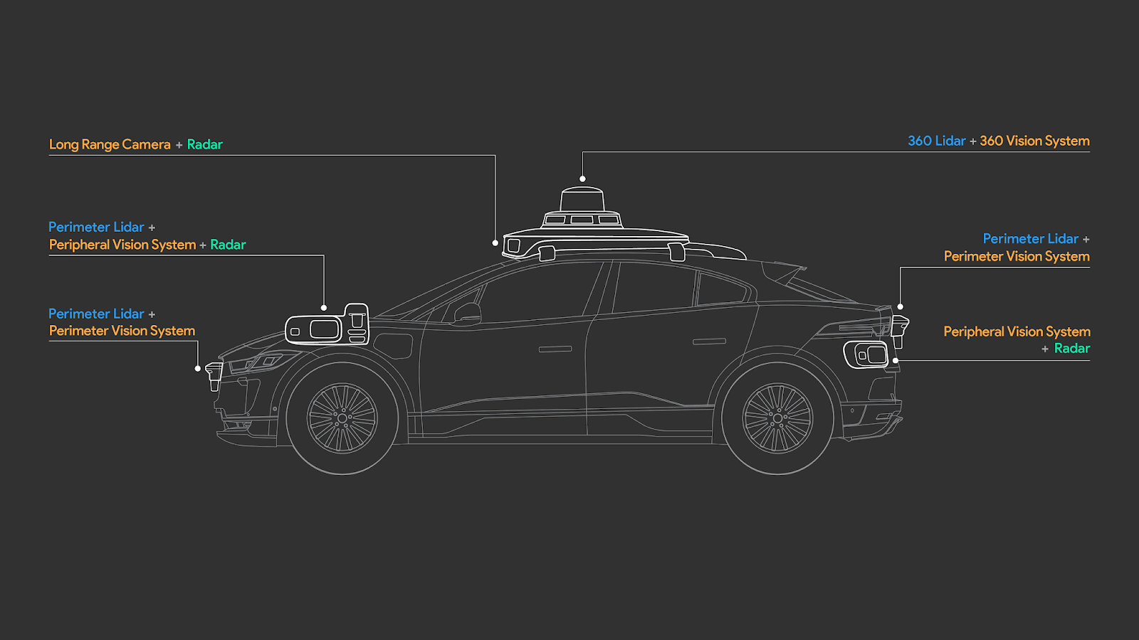
- Lidar is needed for AVs
- Bigger, varied Data is needed for NN training

As new things come about, we should re-evaluate our assumptions. There are people on both sides who won't do this, not just Tesla fans on one side. I'm genuinely in the middle here on the "show me" side - unlike on the EV debate.

Mind you - my statement preceded with "If Cruise can do this ...". So, we have to wait and see - since unlike Tesla, nobody is transparent.
 
What’s the consensus on city streets FSD timeline?
Seems you could do a little research and decide what answer you want to see. My timeline, I requested FSD highway And city streets drove 5 days to qualify (not as hard as many make it out to be) and it was activated. Been using 10.5 on highway and city streets (with camera monitoring attention) for a month and find it to be Very well done. Not perfect, but so far exceeded my expectations personally.
 
  • Like
Reactions: Fernand and stcptl
that Elon probably has a pretty good idea of when it'll be done, but at this point he realizes that he's cried wolf too many times, so he's keeping it to himself.
I doubt it. He is an eternal optimist ... If I were to guess he thinks it will be ready to go out to everyone as Beta ("general availability") in 6 months. My guess is close to 2 years.
 
  • Like
Reactions: stcptl and Phlier
Pony.AI went from 6 months to map and launch in a new city in 2017 to 2 weeks to map and launch in a new city in 2021.
Again the myth that HD map and lidar cannot scale has been debunked at every level.
Anyone still repeating it is knowingly spreading misinformation.
Then, why is Pony.AI not available in top 100 US cities ?

The problem is you are not differentiating between pilot / R&D type press releases vs actual commercialization. In the above example, how many cities did Pony.AI map in 2020 ? How repeatable is that 2 week mapping ? Can Pony run their robotaxi in that new city on all paved roads now ?

As I wrote earlier “show me”. Asking for proof is not “misinformation”.
 
  • Like
Reactions: drtimhill
The absurdity of this discussion about "when it will be ready" is that "ready" has no practical meaning.

Other than the dream Level 5, where the occupants have zero tasks in relation to the car's movements, in deserts, jungles and post-nuclear debris, the formal Level 1-4 definitions don't tell us much about usefulness. I claim that Tesla has offered increasing usefulness at every stage of development.

Using NOA on freeways all the time, I find it takes a lot of fatigue and guesswork off the drives. Very useful. FSD Beta may not be as widely useful, but where it can be successfully employed, on "easy" stretches, it's useful. Besides, it offers great entertainment value when it struggles. I'm enjoying it. If you don't, and suffer buyer's remorse, it may not be for you. If you don't have a Tesla, or only have base autopilot, please tell us about what you do use and your extrapolations.
.
 
The absurdity of this discussion about "when it will be ready" is that "ready" has no practical meaning.
Are you talking about the same "ready" we are talking about ?

We are talking about when will Tesla let anyone who pays/paid for FSD have FSD Beta i.e. it goes from only those screened using safety scores to "general availability" - but still beta. Like NOA.

Very practical and specific meaning.
 
  • Like
Reactions: stcptl
The absurdity of this discussion about "when it will be ready" is that "ready" has no practical meaning.
True for some guys, false for others, but regardless it's still fun to banter about a bit.

Lots of discussions have no practical meaning, but talking about new and exciting technology is still fun to talk about. Especially for this nerd.

If I only talked about stuff that has practical meaning, I'd be darn near mute... which, according to my wife, might be a good thing...
 
Then, why is Pony.AI not available in top 100 US cities ?
Because self driving cars isn't just about maps? How is it hard to understand that mapping isn't the issue?
The problem is you are not differentiating between pilot / R&D type press releases vs actual commercialization.
Everything is still R&D when it comes to L4+ systems even systems deployed commercially (waymo, autox, etc), you still have to deal with depot management, dispatching, fleet maintenance, customer support, routing, etc. The logistics isn't as simple as you think, even then software is always improving nothing is at a standstill.
In the above example, how many cities did Pony.AI map in 2020 ? How repeatable is that 2 week mapping ? Can Pony run their robotaxi in that new city on all paved roads now ?
Not sure what this line of questioning is supposed to prove. The fact is they reduced their mapping tech from needing 6 months to 2 weeks. As they outlined this is from going completely manual to mostly automated.
As I wrote earlier “show me”. Asking for proof is not “misinformation”.
The proof has already been shown. Mobileye has a HD map of several countries and growing to support their door to door Supervision system. Huawei is mapping 24 new cities per year to support their door to door Autopilot system in china.

The difference between Huawei and pony.ai is that Pony.AI is developing L4 driverless cars so unless their system gets good enough to run a service in those cities it serves little purpose other than to help in the improvement of their system to map new cities (which is why they pick select cities).

So Pony.AI isn't going to pointlessly map 100 cities to prove they can map a city in 2 weeks.

Huawei on the other hand is selling L2+ systems with a driver. Therefore they will utilize the maps immediately to support their L2 system.
Therefore they have a reason to map hundreds of cities hence why they are mapping 24 per year.
 
Last edited:
The only point of contention is which approach/company we believe/trust more when it comes FSD

Did you know about this history of GM/Cruise w.r.t. "trustability" ?


General Motors Co laid out its vision for self-driving vehicles on Thursday, telling investors it planned a commercial launch of fleets of fully autonomous robo-taxis in multiple dense urban environments in 2019, in a challenge to rivals such as Alphabet Inc’s Waymo.​
 
Not quite. Yes, Waymo and Cruise need cameras but Waymo and Cruise also use 360 lidar to detect, track and classify cars, pedestrians, cyclists etc... Lidar is used for a lot more than just localization on a HD map. They use lidar as a complement to camera vision because there are cases where lidar is better than cameras, for example, driving into the sun where cameras can get blinded or driving at night in pitch darkness where cameras may see poorly but in both these cases, lidar will still work great.

In the top part of the video, we see what the new Waymo lidar sees. We see that the Waymo lidar is able to see objects like cars and pedestrians with great accuracy even at night:


Note around the 1 mn mark, lidar sees an occluded worker who comes out from behind a parked car at night.
Waymo path planner is much more stable than Teslas. The Tesla planner is what creates a lot of the problems. It is constantly jumping around and shooting off in different directions and often picks one of these wrong directions to follow.
 
Not quite. Yes, Waymo and Cruise need cameras but Waymo and Cruise also use 360 lidar to detect, track and classify cars, pedestrians, cyclists etc... Lidar is used for a lot more than just localization on a HD map. They use lidar as a complement to camera vision because there are cases where lidar is better than cameras, for example, driving into the sun where cameras can get blinded or driving at night in pitch darkness where cameras may see poorly but in both these cases, lidar will still work great.
Do you know for a fact that they use Lidar to "detect, track and classify cars, pedestrians and cyclists"? Lidar (or, at least, cost effective lidar) tends to have rather low resolution to do this kind of recognition. Mostly, lidar can say tell you there is a biggish "something" moving with a certain approach velocity in a certain direction at a certain distance. But filling in the "something" just from the lidar data is much harder.

Also, as an active system lidar is subject to cross-interference as the percentage of cars using it increases (this has already been discussed in the literature). Contract this with passive cameras, which actually benefit from many cars with (say) headlights turned on.
 
Do you know for a fact that they use Lidar to "detect, track and classify cars, pedestrians and cyclists"? Lidar (or, at least, cost effective lidar) tends to have rather low resolution to do this kind of recognition. Mostly, lidar can say tell you there is a biggish "something" moving with a certain approach velocity in a certain direction at a certain distance. But filling in the "something" just from the lidar data is much harder.

Yes. Waymo uses very high resolution lidar that is able to separate different objects and detect and classify objects.

"At Waymo, lidar is core to our sensor suite, with its ability to perceive objects and other road users with industry-leading resolution, up to hundreds of meters away, across a range of conditions."


"lidar paints a 3D picture of its surroundings, allowing us to measure the size and distance of objects around our vehicle, whether they're up close or over 300 meters away. Lidar data can be used to identify objects driving into the sun on the brightest days as well as on moonless nights."


Here is an example of their lidar point cloud where you can see it differentiate between two pedestrians walking close to each other in the distance.

LidarBlog_Sept22.png


You can also check Waymo's other blogs as well as their research papers for more on their lidar's ability to detect and classify objects.

Also, as an active system lidar is subject to cross-interference as the percentage of cars using it increases (this has already been discussed in the literature). Contract this with passive cameras, which actually benefit from many cars with (say) headlights turned on.

I don't know much about this but I would imagine that Waymo has found some type of solution since they use lidar. I've certainly not heard of Waymo having any issue from lidar cross interference. It is probably some type of software solution or perhaps they rely on sensor fusion to resolve any cross-interference. Remember they also use camera vision a lot too. But it certainly does not seem to be an issue for Waymo AFAIK.
 
Last edited:
Both are great, but i think this can be done with cameras as well just maybe not the ones teslas are currently using (like stereoscopic and hyperspectral like techlinkcenter.org/technologies/hyperspectral-3d-vision-sensor-for-autonomous-vehicles-and-unmanned-systems/2f0cd3d1-94d0-473b-8566-31f43c3363bf) and having better driving software.
 
Last edited: