Welcome to Tesla Motors Club
Discuss Tesla's Model S, Model 3, Model X, Model Y, Cybertruck, Roadster and More.
Register

[UPDATED] 2 die in Tesla crash - NHTSA reports driver seat occupied

This site may earn commission on affiliate links.
Someone asked about the 911 call timing. I recall posting an article (with video) of the 911 call stories. Think the first call timing was mentioned within*, but no time to check back right now through posts. Was from KPRC2(?) I believe.
* found article and it did not specify the timing, maybe it was mentioned in the Fire Marshalls report?

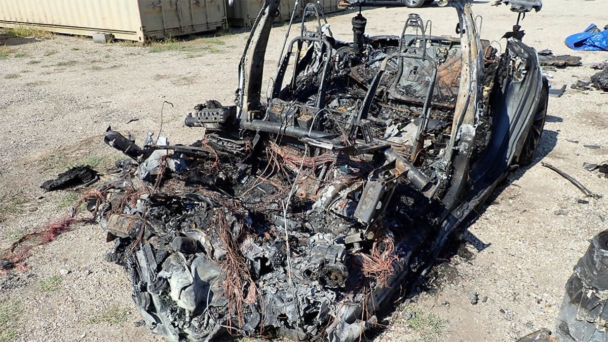
Super bad luck running over the culvert and manhole cover which likely ripped open the battery shield. Otherwise woukd have possibly been just an accident with a tree and survivable with no fire.
 
Last edited:
Regarding timing, FWIW: NTSB says accident occurred at 9:07PM. (This report, presumably based on video evidence timing (which presumably was synced to real-world time).)

From other reporting, as near as I can tell, it sounds like the fire department was dispatched at 9:24PM. So that's about 17 minutes until someone noticed (potentially). And 29 minutes from incident until arrival on scene!

Perhaps someone knows when the 911 call went out? I couldn't find that information and not aware of public transcripts (which would have the time).


View attachment 661107

I have to say that the timing of dispatch at 2124 to arrive on scene at 2136 is shockingly bad. It's exactly one mile from the fire station to the front gate at Carlton Woods. A route that involves one left turn and one right turn. So 12 minutes is a pretty lackluster effort on the part of the FD, if these times are true.
 
....And you would be 100% wrong.

While the system CAN see that seam and at times DOES show it on the screen as a lane delineation, it's very inconsistent. It flickers on and off. And even when it DOES, you still do not get the "gray steering wheel" on the screen and if you try to activate AutoSteer, you get the warning tone and the "Autosteer is unavailable" warning displayed on the screen.
You have be skilled at it - you can activate. You have to do it at the right time - and yes I know when you can activate and when you can't. I can do it near my house - where even the center seam isn't visible. As I said it is inconsistent. As you can see from this thread - I've spent a considerable amount of time on AP (Wiki - Tracking FSD Feature Complete).

But you are missing the point.

AP couldn't have been used here - not because it can't be activated but because
- AP doesn't accelerate that fast
- AP doesn't go 5 mph more than the street speed.

You're actually the one missing the point. According to your reasons, AP could have been used here. It just wouldn't have been a factor in the crash, according to your points. That's a very different conclusion.

I'm done. Come on down to The Woodlands and see if you can get AP to activate on that road in 500 feet. I'll buy you a beer. ;)
 
  • Like
Reactions: Silicon Desert
Google Maps doesn't have a street view of the park/pond area so I checked out Apple Maps' 2D overhead view and you can see the culvert and manhole cover on the path to the forested area. Apple Maps has some funky 3D mapping of trees here but thought it might help people visualize the area prior to the crash. Looks like there might be 2 manhole covers visible, one by culvert and another closer to the one tree. Could not have gone off the road at a worse point.

Screen Shot 2021-05-10 at 4.46.22 PM.jpeg
 
Last edited:
For me, saying there is a video showing what you say and then the there being a video showing what you say, that’s pretty good evidence what you say is correct.
Several people on this forum said there should be a video from a security camera showing the driver was in the driver seat. Now when we know the video exists, do you agree that we all leave in the same house or at least all had access to the video following your "logic"? Your convincing evidence threshold seems a bit low.
 
What the ... ? And I am not fully killed anyone ...?
I mean like: I have not fully stabbed my wife.... Stabbing includes taking the knife and piercing someone with it. Every time I hold a knife in my hand, which is one part of stabbing, I feel I am not fully stabbing someone.
 
Last edited:
Google Maps doesn't have a street view of the park/pond area so I checked out Apple Maps' 2D overhead view and you can see the culvert and manhole cover on the path to the forested area. Apple Maps has some funky 3D mapping of trees here but thought it might help people visualize the area prior to the crash. Looks like there might be 2 manhole covers visible, one by culvert and another closer to the one tree. Could not have gone off the road at a worse point.

I love this site because it gives you all the mapping options for a given coordinate.

GeoHack (30.155278; -95.531111)

Decimal to Degree conversion: Degrees Minutes Seconds to/from Decimal Degrees