I've been trying to find a source for highway traffic utilization or such and so far haven't, so my "evidence" is purely anecdotal at this point. What I do know is that the 401 between Toronto and Windsor is at least 3 lanes (each way) for the entire length except for a very small leg from beyond Windsor towards Chatham. In some areas (for instance, the Waterloo Region), they're tearing out bridges in preparation for widening it to 4 or 5 lanes each way. The last time I drove to Montreal, the 401 was predominantly a measly 2 lanes (each direction) for much of the distance. I have to assume the MOT widened the sections that carry more traffic.
Completing the 401 west corridor would connect southern Ontario with the US Supercharger network and enable/support tourist travel which is very important to the local economy. (Equally important in my mind is the QEW corridor connecting Niagara Falls and Fort Erie/Buffalo).
Thanks and agreed - see below.
It's not hard. Google will lead you to Traffic Volumes from the Ontario Ministry of Transportation. They don't have really recent data, but it's all there.
http://www.raqsb.mto.gov.on.ca/techpubs/TrafficVolumes.nsf/tvweb
It looks to me like the "annual average daily traffic volume" figures (2010) from the 402 interchange to the west end of 401 are 27,000 or less, whereas the figures between the 416 interchange and, well, anywhere further west, are higher. At both ends the volumes are lower - east of the 416 interchange (to the Quebec border) it's on the order of 17,000, whereas at the extreme west end it's typically over 20,000.
For reference, the AADT through the Toronto region goes as high as 400,000. Holy expletive deleted.
The data is there. You guys go ahead now and argue over the interpretation.
")
(Keep in mind that traffic volume includes trucks and buses.)
Thanks to both of you! This MTO dataset of annual average daily traffic on Hwy 401 in 2010 is amazingly detailed! Your and my tax dollars of 2010 worked hard to assemble it all, which is even more impressive since they aren't yet done working on publishing the data for 2011, 2012 and 2013.
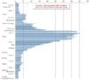
To "mine" your nice data a bit further and also for just a bit of quick fun with a spreadsheet, I've extracted and visualized below a geographically linear sequence (from Windsor to the Quebec border) of the average daily traffic volumes reported for each of the 167 "segments" of Hwy 401. I can spot a couple of interesting and obvious features about Hwy 401 traffic from this, which complements what you already noted:
(1) Looking at the step decreases in daily traffic volumes on the 401 beyond London westwards and beyond the 401/416 split eastwards, there's obviously a lot of intra-Ontario traffic between those 2 reference points. For example, daily volumes are:
(a) over 100,000 between Kitchener/Cambridge and Oshawa, and
(b) over 200,000 between jct 410/403 and Ajax.
(2) Meantime, at only about 20,000, traffic is much tamer at each end towards the Ontario borders (i.e. Windsor to London and 410/416 split to Cornwall and Montreal).
Though we still can't distinguish and exclude trucks and buses:
(a) most 401 traffic (even outside Toronto) is between 2 intra-Ontario end-points, and
(b) beyond the Kitchener-Oshawa core, traffic is much less on the Windsor-London and Brockville-Montreal stretches and is about the same at each end. Maybe this nicely reflects that -yay- Montreal is as important as Michigan to Ontarians' road travels -- and we all do know about the daily westbound Toronto trucking that carries the daily loads of city garbage out to Michigan.
PS: There's an interesting step decrease in volume at the 401/403 split, matching the idea that the London-Hamilton-Niagara route along the 401-403-QEW over into NY state is indeed well used, as jpreiner pointed out. Buffalo and Syracuse, NY, should then be key future targets for Tesla SCs to connect Toronto and the 401 corridor (all completed in 2014, yes?) eastwards to the US and the US east coast, via the existing SC in Albany. Just saw that Tesla already has red dots for both of them on their "2014" map.