Welcome to Tesla Motors Club
Discuss Tesla's Model S, Model 3, Model X, Model Y, Cybertruck, Roadster and More.
Register

Wiki Superchargers Visited

This site may earn commission on affiliate links.
**** NOTE: We have transitioned to a new platform ****
More Info: Supercharging.Life database

This is a friendly contest for Tesla owners to track the number of unique public Superchargers where they have charged

- "Supercharger count" is the number of unique public Superchargers where you have charged (just being there does not count), whether or not you were the person plugging in the vehicle (such as a Valet Parking garage or a Passenger) and whether or not it was your own personal vehicle (such as a rental, a loaner, or a friend's Tesla) as long as you were the one who drove >50% of the distance to reach the charger(s).
- The list of chargers in the supercharging.life database are the ones included in the game. If you think one should be added or removed from the list, let us know.
- Only chargers available to the public without special permission are included in the game.
- Chargers not connected to the grid are not counted.
- Doublet locations like the North/South Supercharger 'pairs' in CT, ME, NH, etc. count as individual locations.
- More than 1 charger at the same address, such as Lenox Square Mall (Atlanta, GA) or Montgomery Mall (Bethesda, MD) count as individual locations when they appear as a separate location on the Tesla Nav screen.
- Inactive competitors will be archived and removed from the leaderboard. Just post an update to be reactivated.

See Supercharging.Life database for info on how to post your own visits to the database (preferred), or post your locations with date visited to this thread and one of the admins will update your list for you. All visits must be posted to this thread - not just entered in supercharging.life. If you are the first in the game to visit a supercharger location, please post to the thread as soon as you can so others know it has been visited.
 
Last edited by a moderator:
Ok, I'm going to get serious about the game now.

I picked up Mebane, NC, on the way back from visiting my son in Chapel Hill. (I already entered it in my column on the spreadsheet.)

Next, clearing all of North Carolina...

mebane_nc_suc.jpg
 
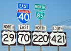
I can think of one highway where you can start off your trip driving northbound and without making any turns or changes of direction of travel end up traveling southbound on the same highway later in the trip. Even the signs switch from northbound to southbound (or vice versa). I'm not sure if it's the only one in the country or not. I'll let you guys try to guess which highway it is. I'm sure some of you have driven on the highway but not sure you've done the entire leg from northbound all the way to southbound in one stretch.
 
  • Like
Reactions: vanjwilson
I can think of one highway where you can start off your trip driving northbound and without making any turns or changes of direction of travel end up traveling southbound on the same highway later in the trip. Even the signs switch from northbound to southbound (or vice versa). I'm not sure if it's the only one in the country or not. I'll let you guys try to guess which highway it is. I'm sure some of you have driven on the highway but not sure you've done the entire leg from northbound all the way to southbound in one stretch.
I-285 around Atlanta? Drive in a circle forever. Probably other cities as well.
 
Day 5 of the Seattle trip. I picked up 2 new Superchargers including another First:

1146. Johnson City - US-281, TX
1147. Llano, TX (First)

We're staying at the Hampton Inn next to the Van Horn Supercharger. We've stopped here many times to charge, use the bathrooms and grab a free coffee, so we're repaying them with a visit. Strangely the Van Horn Supercharger doesn't show up on the TeslaFi map, even though I just completed a full (90%) charge there.

I decided not to bother with the Congress Ave Supercharger this morning since there were road closures for a half-marathon race. I'll get it next time when some of the others have opened.

Day 5.JPG
Day 5b.JPG


There were some spectacular dark clouds and sunset over Big Bend or Mt Livermore as we drove towards Van Horn:

IMG_4632.jpg
E99055AD-106D-4824-A30F-396309DC5D44.JPG
 
I-465 encircles Indianapolis.
I-275 encircles Cincinnati.
I-270 encircles Columbus, OH

Raleigh, NC, tried to solve this by signing I-440 around the city with "Inner" and "Outer", instead of East and West, but it confused so many people, they changed it back to East and West in 2008.

I personally liked "Inner" and "Outer", but since we moved to Charlotte in 2003, I guess they forgot to consult me. ;)

 
I-465 encircles Indianapolis.
I-275 encircles Cincinnati.
I-270 encircles Columbus, OH
Lots of cities with beltways/loops. I-495 in DC. I-695 in Baltimore. I-485 in Charlotte.

But this is my "favorite" wrong-way concurrency, though since reconfigured to be less extreme, around Greensboro NC:
1642995448291.png
Source: Concurrency (road) - Wikipedia (same Wikipedia page as the one @vanjwilson posted).
 
Just for that reason, we ask that people post to this thread when they get a first, preferably with a picture while at the charger, just as @Limited did for Warner Ave. There can be a delay before the spreadsheet is updated, and a further delay until tableau (and the green dots) are updated since that happens once at night after the spreadsheet is updated.
I sometimes do take a picture, but I pay for my charging so I can always send a picture of my charge record on Tesla.com if there is a question

But HOW do people post here from the road? I typically will drive home and then post (assuming I don't pass out from exhaustion first). As the destinations for a First have gotten over 6+ hours (I think the record is 9 hours each way to get the Hood River one) I don't get back the same or even the next day (depending on when I got to the charger). I should probably develop a routine, but at the moment I use that Google Sheetz app to let me edit the Spread Sheet, but I don't know how to post here (especially with a photo) while on the road. I can ALMOST use the browser in the car to get slow same case text posted, but it's ugly.
 
  • Like
Reactions: StephenBrown2
I sometimes do take a picture, but I pay for my charging so I can always send a picture of my charge record on Tesla.com if there is a question

But HOW do people post here from the road? I typically will drive home and then post (assuming I don't pass out from exhaustion first). As the destinations for a First have gotten over 6+ hours (I think the record is 9 hours each way to get the Hood River one) I don't get back the same or even the next day (depending on when I got to the charger). I should probably develop a routine, but at the moment I use that Google Sheetz app to let me edit the Spread Sheet, but I don't know how to post here (especially with a photo) while on the road. I can ALMOST use the browser in the car to get slow same case text posted, but it's ugly.

I post from my cell phone while I’m charging.

Just load up your Watched Threads in Safari and catch up on what’s going on (my preferred method of browsing TMC). Or bookmark the Superchargers Visited thread for even faster access.

You can quickly and easily attach photos from your phone by using the Attach Files button or the picture icon in the edit bar and either inserting the picture as a thumbnail or a full embedded image (my preference).

EF3CD9AA-B5EC-438C-B893-7658C2186A33.jpeg


You can reduce the image size to save space in your TMC image folder (recommended) although some ongoing bug in Apple will sometimes mess up the image rotation when you do that, so edit the image on your phone and wave the magic wand before attaching it to your post.
 
But HOW do people post here from the road?
I recently upgraded from my flip-phone to an iPhone SE. Seems to be able to take pictures and post to this thread. Maybe time to let go of the flip-phone. :)

I can always send a picture of my charge record on Tesla.com if there is a question
Not as much being a question - more of timely notification that the charger has been visited.
 
I sometimes do take a picture, but I pay for my charging so I can always send a picture of my charge record on Tesla.com if there is a question

But HOW do people post here from the road? I typically will drive home and then post (assuming I don't pass out from exhaustion first). As the destinations for a First have gotten over 6+ hours (I think the record is 9 hours each way to get the Hood River one) I don't get back the same or even the next day (depending on when I got to the charger). I should probably develop a routine, but at the moment I use that Google Sheetz app to let me edit the Spread Sheet, but I don't know how to post here (especially with a photo) while on the road. I can ALMOST use the browser in the car to get slow same case text posted, but it's ugly.
I bookmark the following URL in my phone's browser to easily access all threads that are active on TMC
 
  • Like
Reactions: juliusa
Lots of cities with beltways/loops. I-495 in DC. I-695 in Baltimore. I-485 in Charlotte.

But this is my "favorite" wrong-way concurrency, though since reconfigured to be less extreme, around Greensboro NC:
View attachment 759371
Source: Concurrency (road) - Wikipedia (same Wikipedia page as the one @vanjwilson posted).

I hate those sorts of multiplexed highways.

In 1964 when California had the "great renumbering" legislation take effect, the legislature came up with a "one highway, one sign" rule. Gone were the days of multiple routes running concurrently for scores, if not hundreds of miles.

There are many duplexed highways in the state (like the 49/89 picture above.) But those concurrencies tend to be quite short <20 miles.) And California does not have a federal highway co-signed with an interstate highway with the exception of US95 around Needles (I40) and again at Blythe (I10). Most of California's federal highways were either severely truncated (US 6, 50, 101, 395) or eliminated in their entirety (US 40, 40A, 60, 66, 70, 80, 99, 101A, 299, 399, 466).
 
  • Informative
Reactions: Big Earl
Tired of being so close to the next tier so I'm taking a quick drive. @Randy Spencer, wanna join me for a first in Troutdale? 😄
2 hours vs 9 hours, I'll leave you to it.

I recently upgraded from my flip-phone to an iPhone SE. Seems to be able to take pictures and post to this thread. Maybe time to let go of the flip-phone. :)

Not as much being a question - more of timely notification that the charger has been visited.
Oh, my, how did I never try opening this page on my phone. I just assumed it didn't work, or back in the day it didn't. Well look at that. Thanks guys. (I do miss my flip phone, just not it's camera)
 
  • Like
Reactions: juliusa
...But HOW do people post here from the road? I typically will drive home and then post (assuming I don't pass out from exhaustion first)...
I have an Android Tracfone* and keep track of this thread with the default Chrome browser. Posting pictures from the phone is the same as using a desktop computer ("Attach files"), save that I can only use ones taken with the phone. For pictures taken with my real camera I have to wait until I get home to download them. I once posted my daily list to this thread using the browser in my car (MCU1 with LTE), since I didn't have WiFi accesss. That won't work for including pictures, of course.


* Why Tracfone? It is inexpensive and the cost ranges from about $112 a year (for 1200 minutes, 1200 Texts, 1.2 GB data; any unused minutes/texts/data carry over to the new year, so long as the phone activation isn't allowed to expire) to about $150, depending on how many phone minutes and text messages I need in a year. Additional phone minutes, texts or data can be purchased on the phone in seconds. My Tracfone uses the CDMA Verizon network. I generally use free WiFi for internet stuff.
 
I am terrible at this kind of trivia. Can't wait to hear what road it is. I wonder if I've been on it?
The one I was thinking of is US Highway 101 in WA. It crosses into WA heading north at the Astoria Bridge, continues north through Aberdeen and Forks, then turns east to Sequim and finally south to Olympia. I'll have to double check on my next trip, but I believe it is signed East/West on the stretch through the Northern Olympic Peninsula and then flips to North/South between there and Olympia (opposite of what it was from Astoria going up the Pacific coast to Forks.


"Between the intersection with SR 113, on the western edge of the Olympic Mountains, US 101 is signed east–west, and roughly south of the intersection with SR 20, US 101 is signed north–south but having turned around 180°."