


Welcome to Tesla Motors Club
Discuss Tesla's Model S, Model 3, Model X, Model Y, Cybertruck, Roadster and More.
Register
Install the app
How to install the app on iOS
You can install our site as a web app on your iOS device by utilizing the Add to Home Screen feature in Safari. Please see this thread for more details on this.
Note: This feature may not be available in some browsers.
-
Want to remove ads? Register an account and login to see fewer ads, and become a Supporting Member to remove almost all ads.
You are using an out of date browser. It may not display this or other websites correctly.
You should upgrade or use an alternative browser.
You should upgrade or use an alternative browser.
View Waze Incidents on the Tesla browser
- Thread starter fact200
- Start date
-
- Tags
- app Model S User Interface waze
Wow, maybe regional. Mines normal.Something is up with the "spline" calculations for the last couple of days...
Tech_Guy
ALWAYS IN LUDICROUS MODE! P90D>P100D Upgrade
mines all messed up as well, I had traffic arrows going into the ocean and other places that there are not roads etc... I was able to fix it by turning off traffic jams in the settings.
Cooksomerice
Member
I've entered the address and it says website unavailable?
Is your site offline or am I doing something wrong?
I've tried it on my phone as well to no avail.
Is your site offline or am I doing something wrong?
I've tried it on my phone as well to no avail.
ericwol
Member
Any chance to see/track locations of where people are getting tickets? ie actually pulled over and getting the ticket...
OK, I been trying to figure out a way to automate this. We already know the locations that are police traps
") , so I have been logging these locations over time. Down the road, I'm going to filter this data and overlay this on the map to show as high enforcement areas. I wanted to share the data that I have collected so far.
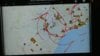
, so I have been logging these locations over time. Down the road, I'm going to filter this data and overlay this on the map to show as high enforcement areas. I wanted to share the data that I have collected so far.The first example is San Francisco. As you can see Broadway, I80/101 are popular spots.
View media item 116359
In Seattle, north I5 near Lynnwood and Everett have high enforcement areas.
View media item 116360
And for Miami...
View media item 116361
If you want to check out your area here is the link to the heatmap of police traps locations.
Code:
https://teslawaze.azurewebsites.net/heatmap/heatmap.htmlAwesome! Thanks Eric.OK, I been trying to figure out a way to automate this. We already know the locations that are police traps
The first example is San Francisco. As you can see Broadway, I80/101 are popular spots.
View media item 116359
In Seattle, north I5 near Lynnwood and Everett have high enforcement areas.
View media item 116360
And for Miami...
View media item 116361
If you want to check out your area here is the link to the heatmap of police traps locations.
Code:
FlatSix911
Porsche 918 Hybrid
OK, I been trying to figure out a way to automate this. We already know the locations that are police traps
The first example is San Francisco. As you can see Broadway, I80/101 are popular spots.
In Seattle, north I5 near Lynnwood and Everett have high enforcement areas. And for Miami...
If you want to check out your area here is the link to the heatmap of police traps locations.
Excellent ... a bit of predictive data analysis
NuclearPowered
Member
It doesn't geolocate my location (Thousand Oaks, CA).OK, I been trying to figure out a way to automate this. We already know the locations that are police traps
The first example is San Francisco. As you can see Broadway, I80/101 are popular spots.
View media item 116359
In Seattle, north I5 near Lynnwood and Everett have high enforcement areas.
View media item 116360
And for Miami...
View media item 116361
If you want to check out your area here is the link to the heatmap of police traps locations.
Code:https://teslawaze.azurewebsites.net/heatmap/heatmap.html
ericwol
Member
Fantastic! Plans to incorporate into your main Tesla Waze application?
Yes
ericwol
Member
Yes, because it does not do that.It doesn't geolocate my location (Thousand Oaks, CA).
Ok, got it. I see it won't let me scroll down to my area so is this for the Bay Area only?Yes, because it does not do that.
Last edited:
ericwol
Member
It's for all of North America. What browser are you using? It works fine on Crome. The are currently 250 thousand points in the data set, so you need some memory to load it.Ok, got it. I see it won't let me scroll down to my area so is this for the Bay Area only?
ericwol
Member
Fantastic! Plans to incorporate into your main Tesla Waze application?
It will show up on the map as enforcement zones like this:
View media item 116363
I was using the Tesla browser like I do with your other apps.It's for all of North America. What browser are you using? It works fine on Crome. The are currently 250 thousand points in the data set, so you need some memory to load it.
ericwol
Member
It worked on my Tesla browser, but yea that browser probably can't handle this very well.I was using the Tesla browser like I do with your other apps.
ericwol
Member
On the 12th day of Christmas Santa brought me.... Elevation!
View media item 116365
View media item 116365
Code:
http://teslawaze.azurewebsites.net/
Last edited:
mspohr
Well-Known Member
Wow Thanks!On the 12th day of Christmas Santa brought me.... Elevation!
View media item 116365Code:http://teslawaze.azurewebsites.net/
SomeJoe7777
Marginally-Known Member
On the 12th day of Christmas Santa brought me.... Elevation!
View media item 116365Code:http://teslawaze.azurewebsites.net/
Nice job, man!
Similar threads
- Locked
- Replies
- 2
- Views
- 787
- Replies
- 20
- Views
- 2K
- Replies
- 36
- Views
- 5K
- Replies
- 111
- Views
- 11K
- Replies
- 36
- Views
- 3K