Welcome to Tesla Motors Club
Discuss Tesla's Model S, Model 3, Model X, Model Y, Cybertruck, Roadster and More.
Register

Wiki Superchargers Visited

This site may earn commission on affiliate links.
**** NOTE: We have transitioned to a new platform ****
More Info: Supercharging.Life database

This is a friendly contest for Tesla owners to track the number of unique public Superchargers where they have charged

- "Supercharger count" is the number of unique public Superchargers where you have charged (just being there does not count), whether or not you were the person plugging in the vehicle (such as a Valet Parking garage or a Passenger) and whether or not it was your own personal vehicle (such as a rental, a loaner, or a friend's Tesla) as long as you were the one who drove >50% of the distance to reach the charger(s).
- The list of chargers in the supercharging.life database are the ones included in the game. If you think one should be added or removed from the list, let us know.
- Only chargers available to the public without special permission are included in the game.
- Chargers not connected to the grid are not counted.
- Doublet locations like the North/South Supercharger 'pairs' in CT, ME, NH, etc. count as individual locations.
- More than 1 charger at the same address, such as Lenox Square Mall (Atlanta, GA) or Montgomery Mall (Bethesda, MD) count as individual locations when they appear as a separate location on the Tesla Nav screen.
- Inactive competitors will be archived and removed from the leaderboard. Just post an update to be reactivated.

See Supercharging.Life database for info on how to post your own visits to the database (preferred), or post your locations with date visited to this thread and one of the admins will update your list for you. All visits must be posted to this thread - not just entered in supercharging.life. If you are the first in the game to visit a supercharger location, please post to the thread as soon as you can so others know it has been visited.
 
Last edited by a moderator:
Day 48
369 miles
Stovepipe Wells in Death Valley had the hottest temperature in the USA (according to @PLUS EV). Thankfully, we went through by about 11 a.m. while it was merely stifling. We could only stand outside the car for a few minutes.

This was my second time through Death Valley with a Tesla. The first was with my 2014 Model S, which had much less than the original 265 miles of range, a strong headwind, and lots of heat. I wasn't quite sure I'd make it to Lone Pine. This time, my 2023 Model X predicted arrival at Lone Pine with 57% SOC from a starting point of 95%, which made for a very different experience.

We love a YouTube channel called Ghost Town Living, in which Brent and his team are working to bring the old mining town of Cerro Gordo back to life. The town is eight miles up a very steep dirt/gravel/rock road that navigates washes and tight spaces to get to the top of the mountain just east of Keeler. When we realized they allow visitors during the day, we decided to go up since I had plenty of range remaining. We chatted with one of the employees and had lunch at the top, overlooking Death Valley to the east and Lake Owens to the West.

The drive up and down took almost an hour each way, given that we were essentially rock crawling.

At Lone Pine, I marveled at the large V3 supercharger site compared with the four V2 stalls I used in 2018. Bernadette loved the museum, too.

We then drove to Mammoth Lake. The temperature dropped into the mid-60s, which was sheer bliss after so many 100+ degree days since leaving Denver. Also, things were green again.

Check-ins for 2024-06-25
- Pahrump, NV (#1741) (Comment: Smith's grocery store, Burger King)
- Bishop, CA (#1742) (Comment: City center parking lot)
- Bishop - Rocking West Dr, CA (#1743) (Comment: Shopping complex, subway )
- Mammoth Lakes - Old Mammoth Rd, CA (#1744) (Comment: City center parking lot )
- Beatty, NV (repeat) (Comment: Revisit per plan )
- Lone Pine, CA (repeat) (Comment: Revisit per plan. Much larger site now. V3, too )
- Mammoth Lakes, CA (repeat) (Comment: Revisit per plan )

Death Valley
1719379095171.png

1719379064557.png


Cerro Gordo
1719379402552.png


Inside the shop/museum at Cerro Gordo. The photos Bernadette is standing next to capture a seminal moment for the town. Heavy D and his crew helped Brent bring up that massive water tank, which California required for the sprinkler system in the rebuilding of The American Hotel. Watch the episode.
1719379528657.png

1719379553151.png

1719379580163.png

1719379623457.png


Lone Pine
1719379693799.png


1719378995686.png
 
Curious if you are carrying a spare tire and jack. Flat tires would be my main concern with a Tesla.
Since I have a separate set of winter tires I decided to bring one front tire. The Tesla X has staggered tires, meaning that the rear tires are slightly wider than the front tires. I read that I could use the smaller tire as a spare for the rear. The only place that I thought made sense to store the tire was between the two captains' seats. I bought a set of tire bags in order to contain the smell of the spare tire. There is space within the spare wheel to coil and store the 220V and 120V extension cords. I am also packing a tire plug kit. I had never plugged a tire before but my son-in-law has a ranch and I was able to help him plug a couple of trailer tires so I kinda know what to do.
I have some mileage on the all season tires. I would recommend a new set of tires for an Alaskan road trip. The tires take quite a beating.
And so far I have found that Tesla X tires are not in stock in Anchorage.
 
We have seen very little construction. The most construction was between Delta Junction and Fairbanks. The Klondike highway was fair, hard-pack and some potholes. No construction. I could not do FSD since there were no lane markings and I had to manually steer around larger potholes.
Are we talking about the same highway? I was asking about the Klondike between Whitehorse and Dawson City. Whole sections of that were torn up last summer, but all the rest of it was paved and striped.
 
The Klondike highway between Whitehorse and Dawson City shows as closed due to wild fires. It was closed the day before we did this route, and was closed a couple of hours after we went through. We could see smoke on the route. Looks like we just lucked out. Be sure to check road conditions at 511 Yukon
On the way back to Colorado in a week or so we will take highway 2 so looks good so far.
 
We love a YouTube channel called Ghost Town Living, in which Brent and his team are working to bring the old mining town of Cerro Gordo back to life. The town is eight miles up a very steep dirt/gravel/rock road that navigates washes and tight spaces to get to the top of the mountain just east of Keeler. When we realized they allow visitors during the day, we decided to go up since I had plenty of range remaining. We chatted with one of the employees and had lunch at the top, overlooking Death Valley to the east and Lake Owens to the West.
Good for you!

You are most fortunate that this place was sold a couple years' back.

Around 1995, I was going to meet my best friend in June Lake for a long weekend with our youngish sons. I crossed over from the Valley through the park while he drove up from El Lay. He had heard about Cerro Gordo, and he had about 4 hours to burn before we were meeting late that afternoon. He drove his Lincoln up that narrow dirt road only to be greeted by a grizzled shotgun toting dude who aimed his gun at his car yelling, "What the [bleep] are you doing up here?"

My friend replied that he saw the sign indicating that there were tours available while he fished out a twenty to hand to the man. Immediately the gun was lowered, he grabbed the twenty and gave them a one-hour tour. "Tell all your friends," he said as they departed.
 
Since I have a separate set of winter tires I decided to bring one front tire. The Tesla X has staggered tires, meaning that the rear tires are slightly wider than the front tires. I read that I could use the smaller tire as a spare for the rear. The only place that I thought made sense to store the tire was between the two captains' seats. I bought a set of tire bags in order to contain the smell of the spare tire. There is space within the spare wheel to coil and store the 220V and 120V extension cords. I am also packing a tire plug kit. I had never plugged a tire before but my son-in-law has a ranch and I was able to help him plug a couple of trailer tires so I kinda know what to do.
I have some mileage on the all season tires. I would recommend a new set of tires for an Alaskan road trip. The tires take quite a beating.
And so far I have found that Tesla X tires are not in stock in Anchorage.
Is the tire mounted on a wheel or is it just a tire? I have an extra tire due to a recent mishap, but don't have an extra wheel for this car. The new S has a staggered setup as well which is something I'm not thrilled about. Anyone know if there is a certain size of tire that can be used on both front and rear in this car? The extra I have is the wider rear, which I'm assuming cannot be used on the front wheels. If you just carry the extra tire, you could still need a tow, but at least you won't be stuck in some place like Tok for a week waiting for a tire to be delivered. With my recent mishap, I was stuck in Amarillo without a car for 30 hours and that was bad enough! (Incidentally Amarillo gets my vote for least walkable city in America lol)
 
Check-ins for 2024-06-26
- Bispingen-Behringen, Germany (#627) (First to check-in)

End of vacation - picking up the one new supercharger on this route

I spent a few days in Lübeck back in November 1998 for an international Holocaust conference. I believe it was one of the first of its kind to take place in Germany. Many survivors told their stories in all sorts of different languages and I also remember being in awe of the translators' abilities. Everything was translated into both German and English and some of them were fighting through tears to do so. This was of particular interest to me since I attended with a group from my university's German department. It was the first time I realized that I had no shot at becoming a professional translator :)

I really enjoyed the city, though my memory has faded sufficiently that I don't remember much about it. I did learn something about the Hanseatic League when I inquired about the HL license plates (also explained the HH plates in Hamburg!).
 
Is the tire mounted on a wheel or is it just a tire? I have an extra tire due to a recent mishap, but don't have an extra wheel for this car. The new S has a staggered setup as well which is something I'm not thrilled about. Anyone know if there is a certain size of tire that can be used on both front and rear in this car? The extra I have is the wider rear, which I'm assuming cannot be used on the front wheels. If you just carry the extra tire, you could still need a tow, but at least you won't be stuck in some place like Tok for a week waiting for a tire to be delivered. With my recent mishap, I was stuck in Amarillo without a car for 30 hours and that was bad enough! (Incidentally Amarillo gets my vote for least walkable city in America lol)
Tire is mounted on a wheel. These are a set of tires/wheels I use in the winter. I am using one of front tires since it is the narrower one and I assume (hope) that it will work fine on the rear.
 
Are we talking about the same highway? I was asking about the Klondike between Whitehorse and Dawson City. Whole sections of that were torn up last summer, but all the rest of it was paved and striped.
My bad. The "Top of the World" highway from Dawson City towards Tetlin Junction was mostly hard-pack. Paved within a few miles of the border crossing. Seems to me like a road grader is used to smooth the dirt road way.
The Klondike highway between Whitehorse and Dawson City had some major construction where it looked like the road was being straightened but the work was being done hundreds of feet away and was not impacting travel on the current road.
We had little delays.
There was a section that was heavily graveled (not paved) and wide where our car got hit by a rock from a bus sized RV traveling really fast downhill.
 
I really enjoyed the city, though my memory has faded sufficiently that I don't remember much about it. I did learn something about the Hanseatic League when I inquired about the HL license plates (also explained the HH plates in Hamburg!).
I think it's quite impressive to still remember that 👍

I learned that the Holsten Tor is so much lower than the ground around because it actually sank into the ground.

 
I think it's quite impressive to still remember that 👍

I learned that the Holsten Tor is so much lower than the ground around because it actually sank into the ground.

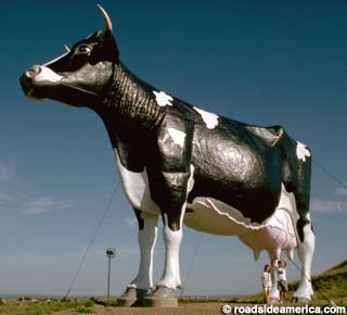
I guess I've spent too long driving around the US because I was imagining a gate made out of a giant cow until I opened your picture. Of course that would be the Holstein cattle that are so common in North America :cool: Surely some place in Iowa or something has a giant cow sculpture they could donate!


EDIT: after doing some minor research, it looks like North Dakota is the place! Salem Sue is the world's largest Holstein cow :)

 
Day 49
158 miles
A picture-perfect day in Yosemite

Check-ins for 2024-06-26
- El Portal, CA (#1745) (Comment: Hotel. No internet available for the car or our phones. Checking in 10 minutes after the session )
- Fish Camp, CA (#1746) (Comment: Tenaya at Yosemite Lodge)
- Oakhurst, CA (#1747) (Comment: The Oakhurst Inn at Yosemite )
- El Portal, CA (repeat) (Comment: second attempt. connected to Starlink this time)

Tomorrow (Friday) is the last day of the year when you can enter Yosemite without a pre-purchased time-slotted pass, which means we visited less than 48 hours before the summer mass crowds. In other words, we got super lucky with our timing. Even better, we followed the sun throughout the day and it was always at least slightly behind us. I have so many great photos from the day, but I'll try to be selective. TMC limits me to 10 anyways.

We entered Yosemite from the east via Tioga Road (from Mammoth Lakes). We exited the the traditional four-season entrance on he west side to collect the El Portal supercharger (more on this drama in a minute). We completed our visit by driving to the south exit to collect the Fish Camp supercharger. This means we used every publicly available park access in one day.

We and the car had virtually no cell coverage throughout the day. You can see this in my map below. All of those straight lines represent the time periods over which TeslaFi couldn't connect to the vehicle.

The El Portal supercharger has Starlink, but I didn't know it when we arrived, and my car did not connect to it. Therefore, TeslaFi didn't record the visit, which was frustrating because it left a big gap in my TeslaFi map. When I was whinging about this in a group chat, @israndy said it had Starlink. We'd gone back into the park and were preparing to head for Fish Camp, but Bernadette was a trooper and let me use another 45 minutes to go back to El Portal and try to connect to Starlink. Initially, Starlink was trying to connect but was saying it couldn't get an IP address. I rebooted the MCU, and that solved the problem. With the car connected, I added another 10kWh to ensure we gave TeslaFi enough time to register the charge session. I couldn't check TeslaFi while charging because my phone didn't have cell service. When we returned to the park, I found a spot that allowed my phone to connect. I confirmed that TeslaFi got the session.

This was my first time on Tioga Road, and I loved it. I liked it more than the other parts of Yosemite (except for maybe Tunnel View). But, wow, it is remote.

And Enty suffered some battle damage today. When we parked to have some lunch at Yosemite Valley Vista Point, we parked in an end spot with a view. Unfortunately, the parking spot was oddly shaped, and I misjudged where I was. The X is hard to know where your front corner is anyway, and I dropped off the pavement with the left front tire. The front valence came down on a rock. The worst damage we can find is that it popped the wheel arch aero shield out. Bernadette got it somewhat back in place, but I'm hoping someone in the Bay area could help me get the quick connects reseated. Maybe @bmah? The scrapes are all on the bottom, FSD still works, and there is no visible damage to anything important.

When we arrived in Fish Camp, I couldn't find the superchargers, so I went to the lodge and asked the bellman. He looked at me and said: "I think they are down." When I told him that the car showed them as online, he shrugged and pointed me in the right direction. I told him I'd report back. Ten minutes later, I was, much to his surprise, back. I noted they worked fine and showed him how to use the charger display on the MCU to get real-time status. He then asked if I'd already charged, and he seemed genuinely surprised when I said I had. We talked a bit more about charging speeds, and then we moved on. Maybe he is a little more enlightened now.

Tuolumne Meadows (this was one of our first views inside the park)
1719467746038.png


Tenaya Lake
1719467821928.png


Half Dome looking west from Olmstead Point
1719467880815.png


The wildflowers were blooming!
1719467933098.png


Yosemiti Valley looking north from Tunnel View
1719468032116.png


There were a ton of dead trees from fires throughout the park. They also seemed to be dying from something else, as many single trees were dead with no visible fire damage. It sounds like this might be from Bark Beetles. As always in today's biosphere, climate change is worsening everything for the trees and the ecosystem. Climate Change exacerbates drought and the intensity and frequency of fire, to name two key impacts. These also stress the trees, which makes them more susceptible to bark beetles and other challenges.
1719468865850.png


Enty's battle damage
1719467978623.png


1719467351135.png
 
My bad. The "Top of the World" highway from Dawson City towards Tetlin Junction was mostly hard-pack. Paved within a few miles of the border crossing. Seems to me like a road grader is used to smooth the dirt road way.
The Klondike highway between Whitehorse and Dawson City had some major construction where it looked like the road was being straightened but the work was being done hundreds of feet away and was not impacting travel on the current road.
We had little delays.
There was a section that was heavily graveled (not paved) and wide where our car got hit by a rock from a bus sized RV traveling really fast downhill.
That makes sense. Sounds like the Klondike is in better shape a year later, which is good. The potholes last year were so bad they were making the local Whitehorse news. The Top of the World highway was a relief in comparison. And that section on the US side is such nice asphalt it's almost comical.

I saw that windshield damage in your previous post. I was really paranoid about that, but didn't manage to get any damage until I was back on the Yellowhead after the whole trip up to Alaska and back. Sorry luck didn't work out on your side.
 
This means we used every publicly available park access in one day.
Gonna have to pick a nit here.

There are four entrances to Yosemite: the three you availed yourself of and the entrance on SR120 that goes past the SC at Groveland. If you had continued west (instead of heading south into the valley) at Crane Flat, you would have exited the park onto the continuation of SR120.

Regardless, just a wonderful undertaking! I don't think Tioga Road was open this time last year as they were dealing with 25-30 feet of snow and the corresponding road repair and maintenance after a winter closure. It is remarkable that the weather can be so pleasant at Tuolumne Meadows yet 12 miles east be in triple digits.

Send me a message if you are heading to Frezzno on your exit from the park. I'll try to meet you at one of the local SC.
 
  • Like
Reactions: israndy