A new permit has been filed for a supercharger in Saint Regis, MT. Building is proposed to begin on 5/5/23.
@Big Earl
@Big Earl


You can install our site as a web app on your iOS device by utilizing the Add to Home Screen feature in Safari. Please see this thread for more details on this.
Note: This feature may not be available in some browsers.
Interesting location - across the street from the travel center?
I am hoping they are going to develop this area out and make it a lot by itself. This exit is always crazy busy in the summer during tourist season. This doesn't solve traffic along I-90 as much as it fixes an issue that has existed for the majority of traffic going Northbound out of Saint Regis to larger areas like Kalispell. Before this supercharger went in you had to backtrack 20 miles to supercharge to make the whole journey in almost all but the longest range models.Based on the permit address and longitudes your Supercharge.info cone is correct, but map satellite and StreetView say that's just a dirt track/grassy area and the lot to east of the buildings would make some more sense. But maybe those images are out of date, or Tesla will pave that area.
The place is consistent with the earlier Town Pump deal mentioned by @MarcoRP:
Either way it's a Splitter!
And just to clarify, these are dig tickets or locate requests. Usually it means construction is starting but sometimes these are used for design work (seeing if the project is feasible with utilities in the area). Since digging is commencing it usually means a permit has been issued but these tickets have nothing to do with actual building permits. Many locate requests are filed before permits are issued.A new permit has been filed for a supercharger in Saint Regis, MT. Building is proposed to begin on 5/5/23.
@Big Earl
Interesting... Maybe they're finally developing this lot into something? I am not surprised that they own this lot. The travel center is LITERALLY the only thing keeping Saint Regis on the map. Without it there's no reason to stop here.I did some sleuthing, and the same LLC owns both the travel center and the address on the locate ticket. Occam's razor.
If it weren't there, something else would be there in its place, like a truck stop. It's a fairly major hopping on/off point for I-90 travelers heading to Glacier NP and the surrounding area.Interesting... Maybe they're finally developing this lot into something? I am not surprised that they own this lot. The travel center is LITERALLY the only thing keeping Saint Regis on the map. Without it there's no reason to stop here.
The dig ticket states work started last week. We will have to wait for someone to pass through to verify it's there.Tesla map shows St. Regis as Q2 '23 and the rest of the new MT locations (Billings, Laurel, Belgrade, Butte, Missoula) as Q3 '23 and Kalispell as Q4. The additional Bozeman location isn't on their map at all.
Not that you can rely on the find us map for accuracy but notable that this one looks to be first up of their new MT SC locations.
Dig tickets are notorious for stating a work to begin date that is not actually when work will begin. Look at the CdA expansion. Blackstone filed a dig ticket 1/11/23 with work to begin 1/14/23. They just filed a new one yesterday as no work has happened since the initial ticket.The dig ticket states work started last week. We will have to wait for someone to pass through to verify it's there.
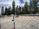
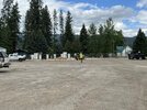
That pin doesn’t look quite right. I know from being in the PNW most sat photos on google are 5 years old so not great for things like this. The second photo above with the building in the background looks like googgle street view from the edge of the dog park. That means no trees in the middle and the chargers going against the small white roofed building in the middle of this photo. Compare with bing below and you’ll see no trees. @ImScotty where were you standing for the first picture from farther back? Can you comment on whether there are new or removed buildings?Based on the photos, the pin should be moved to about 47.298873, -115.099205, far back in the lot.
In the photos above you can see the building to the left and the church further back and to the right.
View attachment 941108
I think you're right that if the dot represents the middle of the parking stalls the dot should be a bit further left and maybe up a bit.That pin doesn’t look quite right. I know from being in the PNW most sat photos on google are 5 years old so not great for things like this. The second photo above with the building in the background looks like googgle street view from the edge of the dog park. That means no trees in the middle and the chargers going against the small white roofed building in the middle of this photo. Compare with bing below and you’ll see no trees. @ImScotty where were you standing for the first picture from farther back? Can you comment on whether there are new or removed buildings?